IMAGES TAKEN NEAR TO
Church Hill, WIGTON, CA7 8NA
Introduction
This page details the photographs taken nearby to Church Hill, CA7 8NA by members of the Geograph project.
The Geograph project started in 2005 with the aim of publishing, organising and preserving representative images for every square kilometre of Great Britain, Ireland and the Isle of Man.

There are currently over 7.5m images from over14,400 individuals and you can help contribute to the project by visiting https://www.geograph.org.uk
Image Map
Images are licensed for reuse under creativecommons.org/licenses/by-sa/2.0
Notes
- Clicking on the map will re-center to the selected point.
- The higher the marker number, the further away the image location is from the centre of the postcode.
Image Listing (16 Images Found)
Images are licensed for reuse under creativecommons.org/licenses/by-sa/2.0
Image
Details
Distance
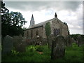
1
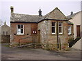
Westward Parish Room
Built by subscription in 1828. The adjoining building was probably the school.
Image: © Bob Jenkins
Taken: 13 Jan 2006
0.03 miles
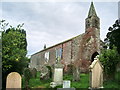
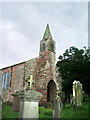
2
Westward Church
The gravestones here are large sandstone and crowd the church.
Image: © Bob Jenkins
Taken: 13 Jan 2006
0.03 miles

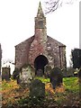
8
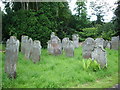
Graveyard, St Hilda's Church, Westward
Nearly all the gravestones were of a deep red sandstone
Image: © Alexander P Kapp
Taken: 8 Aug 2007
0.10 miles
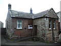
9

Steps
Steps used for helping horse riders to mount their horse
Image: © Alexander P Kapp
Taken: 8 Aug 2007
0.10 miles