IMAGES TAKEN NEAR TO
WIGTON, CA7 8LX
Introduction
This page details the photographs taken nearby to CA7 8LX by members of the Geograph project.
The Geograph project started in 2005 with the aim of publishing, organising and preserving representative images for every square kilometre of Great Britain, Ireland and the Isle of Man.

There are currently over 7.5m images from over14,400 individuals and you can help contribute to the project by visiting https://www.geograph.org.uk
Image Map
Images are licensed for reuse under creativecommons.org/licenses/by-sa/2.0
Notes
- Clicking on the map will re-center to the selected point.
- The higher the marker number, the further away the image location is from the centre of the postcode.
Image Listing (10 Images Found)
Images are licensed for reuse under creativecommons.org/licenses/by-sa/2.0
Image
Details
Distance
1
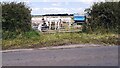
Cows at fieldgate on northeast side of rural road southeast of Wiza Farm
Image: © Roger Templeman
Taken: 8 Jul 2024
0.17 miles
2
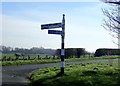
Sign post near Red Dial and Boltonwood Lane
The sign for Bolton New Houses and Sandale is pointing the wrong way!
Image: © Robert Matin
Taken: 6 Apr 2019
0.20 miles
3
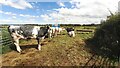
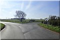
Field with cows on north side of rural road south of Wiza Farm
Image: © Luke Shaw
Taken: 8 Jul 2024
0.20 miles
4
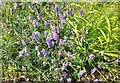
Purple vetch on NW verge of rural road NW of Intack Farm
Image: © Luke Shaw
Taken: 8 Jul 2024
0.21 miles
7
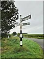
Direction Sign – Signpost northwest of Westward village
Located on the south side of a junction further to the northwest of Westward. Westward parish. 3 arms and pawn finial. See also https://www.geograph.org.uk/photo/6110874 and http://www.geog.port.ac.uk/webmap/thelakes/photos/bvd83.jpg.
Milestone Society National ID: CU_NY2545
Image: © B Todd
Taken: 16 Sep 2023
0.22 miles
8
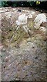
Benchmark on gatepost at T-junction south of Wiza Farm
Ordnance Survey rivet benchmark levelled at 82.604m above Newlyn Datum verified 1971
Image: © Roger Templeman
Taken: 8 Jul 2024
0.23 miles
10
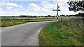
Rural road T-junction south of Wiza Farm
Image gives information on the Cumberland County Council finger signpost on the right hand verge
Image: © Luke Shaw
Taken: 8 Jul 2024
0.25 miles