IMAGES TAKEN NEAR TO
Red Dial, WIGTON, CA7 8LW
Introduction
This page details the photographs taken nearby to CA7 8LW by members of the Geograph project.
The Geograph project started in 2005 with the aim of publishing, organising and preserving representative images for every square kilometre of Great Britain, Ireland and the Isle of Man.

There are currently over 7.5m images from over14,400 individuals and you can help contribute to the project by visiting https://www.geograph.org.uk
Image Map
Images are licensed for reuse under creativecommons.org/licenses/by-sa/2.0
Notes
- Clicking on the map will re-center to the selected point.
- The higher the marker number, the further away the image location is from the centre of the postcode.
Image Listing (6 Images Found)
Images are licensed for reuse under creativecommons.org/licenses/by-sa/2.0
Image
Details
Distance
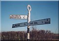
1
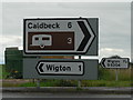
Red Dial: a mile or a country mile?
Depending on which sign you read, Wigton is either 1 mile or 1½ miles from here.
Image: © Chris Downer
Taken: 7 Aug 2008
0.04 miles
2
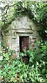
Former Wigton Waterworks building on SE side of A595 west of Sun Inn
Image: © Roger Templeman
Taken: 8 Jul 2024
0.15 miles
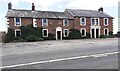
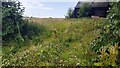
4
Roman Fort, Wigton
The earthworks in the middle distance are part of a large Roman Fort.
Image: © Nigel Monckton
Taken: 2 Oct 2005
0.23 miles
5
Old Direction Sign - Signpost by the B5304, High Longthwaite, Wigton parish
Annulus finial - 3 arms; Cumberland named halo by the B5304, in parish of Wigton (Allerdale District), opposite junction with Cuddy Lonning, near Gerrard House, High Longthwaite.
Surveyed
Milestone Society National ID: CU_NY2546
Image: © Milestone Society
Taken: Unknown
0.23 miles
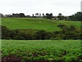
6
Field on NW side of A595 at SW side of Sun Inn
Ordnance Survey documents indicate that a benchmark levelled at 72.143m was verified in 1970 on a gatepost at the left hand side of the field entrance. The entrance has apparently been widened with loss of the gatepost
Image: © Roger Templeman
Taken: 8 Jul 2024
0.24 miles