IMAGES TAKEN NEAR TO
Hesket Newmarket, WIGTON, CA7 8LD
Introduction
This page details the photographs taken nearby to CA7 8LD by members of the Geograph project.
The Geograph project started in 2005 with the aim of publishing, organising and preserving representative images for every square kilometre of Great Britain, Ireland and the Isle of Man.

There are currently over 7.5m images from over14,400 individuals and you can help contribute to the project by visiting https://www.geograph.org.uk
Image Map
Images are licensed for reuse under creativecommons.org/licenses/by-sa/2.0
Notes
- Clicking on the map will re-center to the selected point.
- The higher the marker number, the further away the image location is from the centre of the postcode.
Image Listing (10 Images Found)
Images are licensed for reuse under creativecommons.org/licenses/by-sa/2.0
Image
Details
Distance
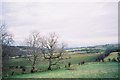
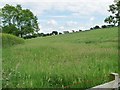
2

Street Head
Footpath to Matthew Rudding crossing fields near Street Head.
Image: © Peter McDermott
Taken: 4 Oct 2009
0.20 miles
3

Low summit north-east of Mickle How
About 226 metres above sea level. Viewed from a spot height of 221 metres.
Image: © Christine Johnstone
Taken: 14 Jun 2016
0.20 miles

5
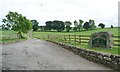
The way to Hudscales from The Street
A public footpath and access track, running southwards from a 221 metre spot height.
Image: © Christine Johnstone
Taken: 14 Jun 2016
0.22 miles
7
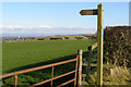
Matthew Rudding
Stile and footpath near Hesket Newmarket
Image: © mauldy
Taken: 18 Feb 2007
0.22 miles
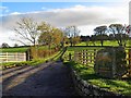
8
Farmland east of Mickle How
Immediately east of the track to Hudscales.
Image: © Christine Johnstone
Taken: 14 Jun 2016
0.22 miles

