IMAGES TAKEN NEAR TO
Pasture Lane, WIGTON, CA7 8JP
Introduction
This page details the photographs taken nearby to Pasture Lane, CA7 8JP by members of the Geograph project.
The Geograph project started in 2005 with the aim of publishing, organising and preserving representative images for every square kilometre of Great Britain, Ireland and the Isle of Man.

There are currently over 7.5m images from over14,400 individuals and you can help contribute to the project by visiting https://www.geograph.org.uk
Image Map
Images are licensed for reuse under creativecommons.org/licenses/by-sa/2.0
Notes
- Clicking on the map will re-center to the selected point.
- The higher the marker number, the further away the image location is from the centre of the postcode.
Image Listing (4 Images Found)
Images are licensed for reuse under creativecommons.org/licenses/by-sa/2.0
Image
Details
Distance
1
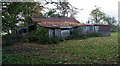
Barn
Barn on Pasture Lane near Hutton Sceugh.
Image: © Peter McDermott
Taken: 4 Oct 2009
0.07 miles
2
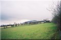
Farmland next to Pasture Lane
Looking south, with Carrock Fell rising beyond.
Image: © Andrew Smith
Taken: 18 Dec 2005
0.07 miles
3
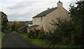
Pasture Lane
House on Pasture Lane near Hesket Newmarket.
Image: © Peter McDermott
Taken: 4 Oct 2009
0.10 miles
4
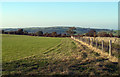
Field adjacent to Pasture Lane
The minor road, Pasture Lane is seen through the fence at the right side of the image; the view is northwards towards Hesket Newmarket.
Image: © Trevor Littlewood
Taken: 28 Sep 2011
0.22 miles