IMAGES TAKEN NEAR TO
Hesket Newmarket, WIGTON, CA7 8HR
Introduction
This page details the photographs taken nearby to CA7 8HR by members of the Geograph project.
The Geograph project started in 2005 with the aim of publishing, organising and preserving representative images for every square kilometre of Great Britain, Ireland and the Isle of Man.

There are currently over 7.5m images from over14,400 individuals and you can help contribute to the project by visiting https://www.geograph.org.uk
Image Map
Images are licensed for reuse under creativecommons.org/licenses/by-sa/2.0
Notes
- Clicking on the map will re-center to the selected point.
- The higher the marker number, the further away the image location is from the centre of the postcode.
Image Listing (5 Images Found)
Images are licensed for reuse under creativecommons.org/licenses/by-sa/2.0
Image
Details
Distance
1
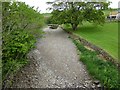
River Caldew runs dry!
The river was flowing happily earlier http://www.geograph.org.uk/photo/4970129
Where has the water gone?
Image: © Russel Wills
Taken: 25 May 2016
0.03 miles
2
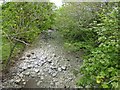
Looking downstream from Millhouse Bridge
Where is the River Caldew?
Image: © Russel Wills
Taken: 25 May 2016
0.04 miles
3
Millhouse
A photograph of the village of Millhouse near Penrith, Cumbria. My first photo for Geograph.co.uk...
Image: © andy
Taken: 11 Jun 2005
0.04 miles
4
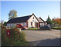
The village hall, Millhouse, Castle Sowerby
A modern building, dated 2002, but nicely finished with quoins at the corners and ball finials on the gables.
Image: © Humphrey Bolton
Taken: 1 Nov 2006
0.05 miles
5
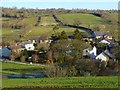
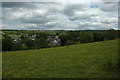
Millhouse, Castle Sowerby
A view over the hamlet from the footpath to Halfcliff Hall.
Image: © Andrew Smith
Taken: 29 Nov 2012
0.10 miles