IMAGES TAKEN NEAR TO
Caldbeck, WIGTON, CA7 8HF
Introduction
This page details the photographs taken nearby to CA7 8HF by members of the Geograph project.
The Geograph project started in 2005 with the aim of publishing, organising and preserving representative images for every square kilometre of Great Britain, Ireland and the Isle of Man.

There are currently over 7.5m images from over14,400 individuals and you can help contribute to the project by visiting https://www.geograph.org.uk
Image Map
Images are licensed for reuse under creativecommons.org/licenses/by-sa/2.0
Notes
- Clicking on the map will re-center to the selected point.
- The higher the marker number, the further away the image location is from the centre of the postcode.
Image Listing (84 Images Found)
Images are licensed for reuse under creativecommons.org/licenses/by-sa/2.0
Image
Details
Distance
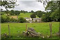
4
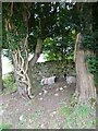
Two old Yews and two not-so-old Ewes
On the outskirts of Caldbeck.
Image: © Oliver Dixon
Taken: 4 Sep 2021
0.07 miles
5
Footpath & barn near Caldbeck
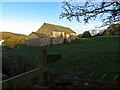
The field barn is Grade II Listed (List Entry Number: 1416127). It was listed for three main reasons: its significant original fabric - an intact field barn, pierced by original openings, which clearly illustrates its original form and function; its date - considered to date from late C17 or C18; regional diversity and character - a farm building type characteristic of the inaccessible parts of the Pennines and Lake District which illustrates the diversity of past farming practice in England.
Image: © Andrew Curtis
Taken: 29 Oct 2017
0.07 miles
6
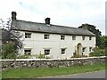
Todcroft
Grade II listed farmhouse probably late 17th century. Now a private house.
Image: © Oliver Dixon
Taken: 4 Sep 2021
0.08 miles
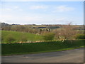
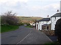
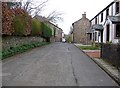
8
Houses at Upton
Viewed from the Cumbrian Way.
Image: © Mick Garratt
Taken: 5 Aug 2010
0.08 miles
10
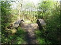
Hump-backed bridge
The Cumbria Way follows the public footpath from Townhead to Hodden Croft in Caldbeck, crossing Gill Beck by a neglected ornamental hump-backed bridge (next photograph Image).
Image: © Adrian Taylor
Taken: 19 Apr 2014
0.09 miles