IMAGES TAKEN NEAR TO
West Woodside, WIGTON, CA7 8BA
Introduction
This page details the photographs taken nearby to CA7 8BA by members of the Geograph project.
The Geograph project started in 2005 with the aim of publishing, organising and preserving representative images for every square kilometre of Great Britain, Ireland and the Isle of Man.

There are currently over 7.5m images from over14,400 individuals and you can help contribute to the project by visiting https://www.geograph.org.uk
Image Map
Images are licensed for reuse under creativecommons.org/licenses/by-sa/2.0
Notes
- Clicking on the map will re-center to the selected point.
- The higher the marker number, the further away the image location is from the centre of the postcode.
Image Listing (14 Images Found)
Images are licensed for reuse under creativecommons.org/licenses/by-sa/2.0
Image
Details
Distance

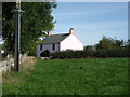
2
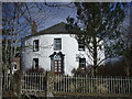
Fiddleback Farm, West Woodside
The house has an unusual circular design
Image: © John Lord
Taken: 27 Mar 2010
0.07 miles
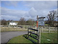
4
Curthwaite
Minor road heading north west towards the A595.
Image: © JThomas
Taken: 17 Sep 2016
0.11 miles
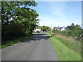
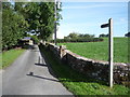
5
Old road, Crofton Bridge
This road, formerly the A595, was bypassed in the early 1960s to avoid a narrow bridge over the River Wampool. The road loops off the A595 and crosses Old Crofton Bridge (photograph Image).
Image: © Adrian Taylor
Taken: 3 Jun 2023
0.11 miles
9
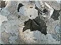
Benchmark, Old Crofton Bridge
Detail of the Ordnance Survey pivot benchmark on the top of the west parapet at the centre of Old Crofton Bridge, (photograph Image) above the River Wampool. The benchmark marks a height of 27.2441m above mean sea level (Ordnance Datum Newlyn) last verified in 1970.
Image: © Adrian Taylor
Taken: 3 Jun 2023
0.17 miles
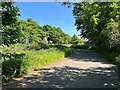
10

Old Crofton Bridge
Crossing the River Wampool, Old Crofton Bridge is on a bypassed section of the A595 road, the new bridge being approximately 30 metres upstream to the east.
There is an Ordnance Survey pivot benchmark on the top of the west parapet at the centre of the bridge (detail photograph Image).
Image: © Adrian Taylor
Taken: 3 Jun 2023
0.17 miles