IMAGES TAKEN NEAR TO
WIGTON, CA7 8AF
Introduction
This page details the photographs taken nearby to CA7 8AF by members of the Geograph project.
The Geograph project started in 2005 with the aim of publishing, organising and preserving representative images for every square kilometre of Great Britain, Ireland and the Isle of Man.

There are currently over 7.5m images from over14,400 individuals and you can help contribute to the project by visiting https://www.geograph.org.uk
Image Map
Images are licensed for reuse under creativecommons.org/licenses/by-sa/2.0
Notes
- Clicking on the map will re-center to the selected point.
- The higher the marker number, the further away the image location is from the centre of the postcode.
Image Listing (12 Images Found)
Images are licensed for reuse under creativecommons.org/licenses/by-sa/2.0
Image
Details
Distance
1
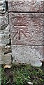
Benchmark on farm building at The Street
Ordnance Survey cut mark benchmark levelled at 65.491m above Newlyn Datum verified 1970
Image: © Roger Templeman
Taken: 27 Jan 2024
0.02 miles
2
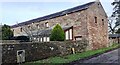
Building at The Street
There is an Ordnance Survey benchmark Image on the near corner, right hand face, of the barn conversion
Image: © Roger Templeman
Taken: 27 Jan 2024
0.02 miles
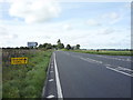
3
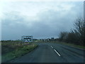
A595, Street House
Heading south west towards Cockermouth.
Image: © JThomas
Taken: 17 Sep 2016
0.04 miles
5
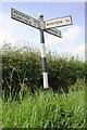
Cumbria finger signpost at junction of B5305 east of Syke Farm
A signpost is shown at this location on the Ordnance Survey 1969 1:2500 map but most of the current one appears more recent
Image: © Luke Shaw
Taken: 3 Aug 2019
0.18 miles
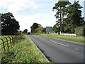
6
Road junction on the A595
Heading south west towards Cockermouth.
Image: © JThomas
Taken: 17 Sep 2016
0.19 miles
7
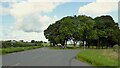
Road junction at Highmoor Park
Highmoor Park surrounded by iron railings has Syke Road to the left in this view and the B5305 road to Wigton to the right
Image: © Kevin Waterhouse
Taken: 23 Aug 2023
0.19 miles
8
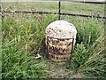
Old Milestone by the A595, north east of B5305 crossroads
Metal plate attached to stone post by the A595, in parish of WESTWARD (ALLERDALE District), East of Street, junction with B5305, on grass verge, on North side of road. Carlisle red stone and curved plate, erected by the Cockermouth & Carlisle turnpike trust in the 19th century.
Inscription reads:-
CARLISLE
10 MILES
COCKERMOUTH
15½ MILES
Grade II Listed. List Entry Number: 1327250
https://historicengland.org.uk/listing/the-list/list-entry/1327250
Milestone Society National ID: CU_CLCM10.
Image: © CF Smith
Taken: 25 Jul 2005
0.22 miles
9
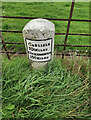
Old Milestone by the A595, north east of B5305 crossroads
Metal plate attached to stone post by the A595, in parish of WESTWARD (ALLERDALE District), East of Street, junction with B5305, on grass verge, on North side of road. Carlisle red stone and curved plate, erected by the Cockermouth & Carlisle turnpike trust in the 19th century.
Inscription reads:-
CARLISLE
10 MILES
COCKERMOUTH
15½ MILES
Grade II Listed. List Entry Number: 1327250 https://historicengland.org.uk/listing/the-list/list-entry/1327250
Milestone Society National ID: CU_CLCM10
Image: © Barbara Todd
Taken: 10 Sep 2023
0.22 miles