IMAGES TAKEN NEAR TO
Kirkbride, WIGTON, CA7 5HL
Introduction
This page details the photographs taken nearby to CA7 5HL by members of the Geograph project.
The Geograph project started in 2005 with the aim of publishing, organising and preserving representative images for every square kilometre of Great Britain, Ireland and the Isle of Man.

There are currently over 7.5m images from over14,400 individuals and you can help contribute to the project by visiting https://www.geograph.org.uk
Image Map
Images are licensed for reuse under creativecommons.org/licenses/by-sa/2.0
Notes
- Clicking on the map will re-center to the selected point.
- The higher the marker number, the further away the image location is from the centre of the postcode.
Image Listing (9 Images Found)
Images are licensed for reuse under creativecommons.org/licenses/by-sa/2.0
Image
Details
Distance
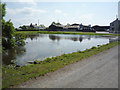
5
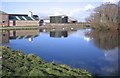
The Swan Pond at Salt Cotes
4 Swans a living here.
Image: © John Holmes
Taken: 18 Feb 2006
0.05 miles
6
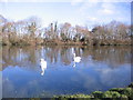
The Swan Pond at Salt Cotes.
Just very photogenic.
Image: © John Holmes
Taken: 18 Feb 2006
0.05 miles
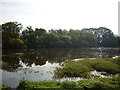
8
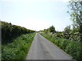
National Cycle Route 72
Heading south west, Salt Coates.
Image: © JThomas
Taken: 28 May 2016
0.10 miles