IMAGES TAKEN NEAR TO
Newton Arlosh, WIGTON, CA7 5HD
Introduction
This page details the photographs taken nearby to CA7 5HD by members of the Geograph project.
The Geograph project started in 2005 with the aim of publishing, organising and preserving representative images for every square kilometre of Great Britain, Ireland and the Isle of Man.

There are currently over 7.5m images from over14,400 individuals and you can help contribute to the project by visiting https://www.geograph.org.uk
Image Map
Images are licensed for reuse under creativecommons.org/licenses/by-sa/2.0
Notes
- Clicking on the map will re-center to the selected point.
- The higher the marker number, the further away the image location is from the centre of the postcode.
Image Listing (6 Images Found)
Images are licensed for reuse under creativecommons.org/licenses/by-sa/2.0
Image
Details
Distance
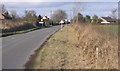
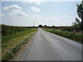
3
Maryholme
A view looking northnortheast along the B5307 at the Maryholme area of Newton Arlosh.
Image: © Phil Williams
Taken: 13 Feb 2006
0.13 miles
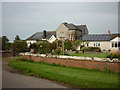
5
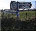
A Sign of the times.
Road directions cycle routes and even walking routes and this really is in the countryside
Image: © John Holmes
Taken: 18 Feb 2006
0.18 miles
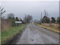
6
National Cycle Route 72
Heading south west from Newton Arlosh.
Image: © JThomas
Taken: 28 May 2016
0.23 miles