IMAGES TAKEN NEAR TO
Fingland, Kirkbride, WIGTON, CA7 5EN
Introduction
This page details the photographs taken nearby to CA7 5EN by members of the Geograph project.
The Geograph project started in 2005 with the aim of publishing, organising and preserving representative images for every square kilometre of Great Britain, Ireland and the Isle of Man.

There are currently over 7.5m images from over14,400 individuals and you can help contribute to the project by visiting https://www.geograph.org.uk
Image Map
Images are licensed for reuse under creativecommons.org/licenses/by-sa/2.0
Notes
- Clicking on the map will re-center to the selected point.
- The higher the marker number, the further away the image location is from the centre of the postcode.
Image Listing (9 Images Found)
Images are licensed for reuse under creativecommons.org/licenses/by-sa/2.0
Image
Details
Distance
2
Direction Sign – Signpost on the B5307 in Fingland
Located on the southwest side of the junction of the B5307 at Fingland. Bowness parish. 3 arms and annulus finial.
Milestone Society National ID: CU_NY2557
Image: © B Todd
Taken: 26 Oct 2023
0.02 miles
3
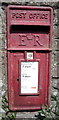
Elizabeth II postbox, Fingland
Postbox No. CA7 116.
See Image] for context.
Image: © JThomas
Taken: 28 May 2016
0.02 miles
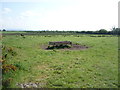
4
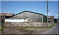
Barn, Fingland
Showing position of Postbox No. CA7 116.
See Image] for postbox.
Image: © JThomas
Taken: 28 May 2016
0.02 miles
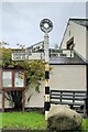
5
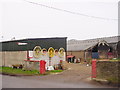
Mid Town Farm, Fingland
More colourful than most farm entrances hereabouts!
Image: © Bob Jenkins
Taken: 6 Feb 2006
0.05 miles
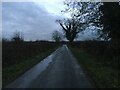
7

Minor road towards Little Bampton
Heading south east from Fingland.
Image: © JThomas
Taken: 28 May 2016
0.12 miles
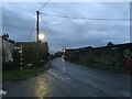
9

Entering Fingland
Heading east on the B5307.
Image: © JThomas
Taken: 28 May 2016
0.21 miles