IMAGES TAKEN NEAR TO
Glasson, WIGTON, CA7 5EB
Introduction
This page details the photographs taken nearby to CA7 5EB by members of the Geograph project.
The Geograph project started in 2005 with the aim of publishing, organising and preserving representative images for every square kilometre of Great Britain, Ireland and the Isle of Man.

There are currently over 7.5m images from over14,400 individuals and you can help contribute to the project by visiting https://www.geograph.org.uk
Image Map
Images are licensed for reuse under creativecommons.org/licenses/by-sa/2.0
Notes
- Clicking on the map will re-center to the selected point.
- The higher the marker number, the further away the image location is from the centre of the postcode.
Image Listing (28 Images Found)
Images are licensed for reuse under creativecommons.org/licenses/by-sa/2.0
Image
Details
Distance
1
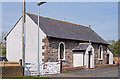
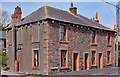
Former Primitive Methodist Chapel - Glasson - May 2017 (1)
Dating from 1844, it is believed this Chapel closed about 1966 and is now a private dwelling.
For information on the Primitive Methodists, see Wikipedia at: https://en.wikipedia.org/wiki/Primitive_Methodism
See also: Image] and Image] .
Image: © The Carlisle Kid
Taken: 1 May 2017
0.01 miles
2
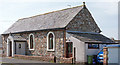
Former Primitive Methodist Chapel - Glasson - May 2017 (2)
For information on this building, see: Image] .
Image: © The Carlisle Kid
Taken: 1 May 2017
0.01 miles
3
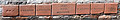
Former Primitive Methodist Chapel - Glasson - May 2017 (3)
Names on the front wall of the former Chapel.
For information on this building, see: Image] .
Image: © The Carlisle Kid
Taken: 1 May 2017
0.01 miles
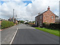
4
Millers Row, Glasson - May 2017 (1)
Old OS Maps give no clue regarding the history of this building. However, the area around Wigton was known for linen manufacture in the 18th Century, although this ended in the mid-1930's.
See also: Image] .
Image: © The Carlisle Kid
Taken: 1 May 2017
0.01 miles
5
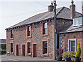
Millers Row, Glasson - May 2017 (2)
See also: Image] .
Image: © The Carlisle Kid
Taken: 1 May 2017
0.01 miles
6
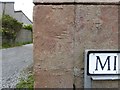
Millers Row street sign
There is an indistinct old Ordnance Survey cut benchmark on one of the large sandstone quoins of the house (detail photograph Image).
Millers Row is on the Hadrian's Wall Path National Trail.
Image: © Adrian Taylor
Taken: 7 Jun 2020
0.01 miles
7
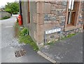
Benchmark, Millers Row, Glasson
Detail of an old, weathered Ordnance Survey cut benchmark on the sandstone quoin of a house on Millers Row (Location photograph Image). The benchmark marks a height of 28.7ft above mean sea level (Ordnance Datum Newlyn).
Image: © Adrian Taylor
Taken: 7 Jun 2020
0.01 miles
9
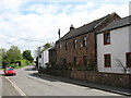
Barrocks House, Glasson
According to the Cicerone Guidebook, Barrocks House is constructed of red sandstone blocks to Roman Wall specification.
The white building beyond Barrocks House is the Highland Laddie Inn (see Image).
Image: © David Purchase
Taken: 2 Jun 2013
0.05 miles