
IMAGES TAKEN NEAR TO
Easton, WIGTON, CA7 5DN
Introduction
This page details the photographs taken nearby to CA7 5DN by members of the Geograph project.
The Geograph project started in 2005 with the aim of publishing, organising and preserving representative images for every square kilometre of Great Britain, Ireland and the Isle of Man.

There are currently over 7.5m images from over14,400 individuals and you can help contribute to the project by visiting https://www.geograph.org.uk
Image Map
Images are licensed for reuse under creativecommons.org/licenses/by-sa/2.0
Notes
- Clicking on the map will re-center to the selected point.
- The higher the marker number, the further away the image location is from the centre of the postcode.
Image Listing (4 Images Found)
Images are licensed for reuse under creativecommons.org/licenses/by-sa/2.0
Image
Details
Distance
1
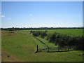
Drainage ditch near Enness House
Viewed from the Hadrian's Wall Path National Trail looking towards Easton, the land to the left of the ditch was once the course of the Carlisle Canal.
Image: © Trevor Harris
Taken: 3 Aug 2006
0.21 miles
2
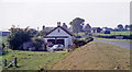
Site of Drumburgh station, 1991
View westward, towards Silloth, also (to the right) Port Carlisle: ex-NBR Carlisle - Silloth line, junction for Port Carlisle. The Port Carlisle branch - long famous for its horse-drawn 'Dandy'- was closed 1/2/32, Drumburgh station closed 1/7/55 and the Silloth line on 7/9/64.
Image: © Ben Brooksbank
Taken: 1 Sep 1991
0.22 miles
4
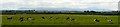
Hadrian's Wall Walk Day 1 - Bowness on Solway to Carlisle 2
The Solway Firth coastal flatlands viewed from the Hadrian's Wall Path east of Drumburgh. Away in the hazy distance are the fells of Skiddaw Forest.
Image: © Bobby Clegg
Taken: 17 Jun 2014
0.24 miles