IMAGES TAKEN NEAR TO
Kirkbride, WIGTON, CA7 5BE
Introduction
This page details the photographs taken nearby to CA7 5BE by members of the Geograph project.
The Geograph project started in 2005 with the aim of publishing, organising and preserving representative images for every square kilometre of Great Britain, Ireland and the Isle of Man.

There are currently over 7.5m images from over14,400 individuals and you can help contribute to the project by visiting https://www.geograph.org.uk
Image Map (Loading...)


Getting Data...Please wait
Leaflet Map data © OpenStreetMap
Images are licensed for reuse under creativecommons.org/licenses/by-sa/2.0
Notes
- Clicking on the map will re-center to the selected point.
- The higher the marker number, the further away the image location is from the centre of the postcode.
Image Listing (18 Images Found)
Images are licensed for reuse under creativecommons.org/licenses/by-sa/2.0
Image
Details
Distance
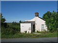
1
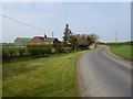
Bungalow at Beckbrow
The road is followed by Hadrian's Cycleway (National Cycle Network route 72).
Image: © Oliver Dixon
Taken: 9 Apr 2017
0.01 miles
2
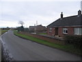
Beckbrow
A view looking south at the hamlet of Beckbrow.
Image: © Phil Williams
Taken: 13 Feb 2006
0.02 miles
6
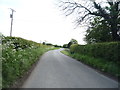
National Cycle Route 72, Beckbrow
Heading south.
Image: © JThomas
Taken: 28 May 2016
0.04 miles
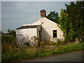
7
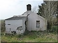
Beckbrow Cottage
See also Image Some further deterioration can be seen compared with 5 years ago.
Image: © Oliver Dixon
Taken: 9 Apr 2017
0.04 miles
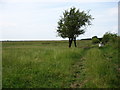
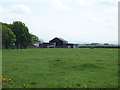
9
Grazing, West Whitrigg
Off National Cycle Route 72.
Image: © JThomas
Taken: 28 May 2016
0.11 miles
10
Field entrance, Longcroft
Off National Cycle Route 72.
Image: © JThomas
Taken: 28 May 2016
0.12 miles