IMAGES TAKEN NEAR TO
Kirkbride, WIGTON, CA7 5BA
Introduction
This page details the photographs taken nearby to CA7 5BA by members of the Geograph project.
The Geograph project started in 2005 with the aim of publishing, organising and preserving representative images for every square kilometre of Great Britain, Ireland and the Isle of Man.

There are currently over 7.5m images from over14,400 individuals and you can help contribute to the project by visiting https://www.geograph.org.uk
Image Map
Images are licensed for reuse under creativecommons.org/licenses/by-sa/2.0
Notes
- Clicking on the map will re-center to the selected point.
- The higher the marker number, the further away the image location is from the centre of the postcode.
Image Listing (11 Images Found)
Images are licensed for reuse under creativecommons.org/licenses/by-sa/2.0
Image
Details
Distance
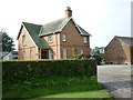
5
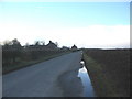
Longcroft
A view looking northwest along the coast road to the hamlet of Longcroft.
Image: © Phil Williams
Taken: 15 Feb 2006
0.10 miles
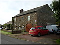
6
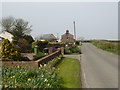
Longcroft
A hamlet on the road to Anthorn. The road is followed by Hadrian's Cycleway (National Cycle Network route 72).
Image: © Oliver Dixon
Taken: 9 Apr 2017
0.10 miles
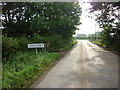
7
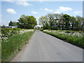
National Cycle Route 72
Heading south east towards Longcroft.
Image: © JThomas
Taken: 28 May 2016
0.12 miles
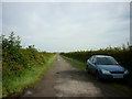
8
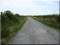
The track to Rogersceugh Farm
A public footpath leading to Bowness-on-Solway follows this farm access track.
Image: © David Purchase
Taken: 27 Jul 2013
0.14 miles
9
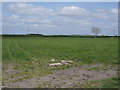
Farmland east of Anthorn
Off National Cycle Route 72.
Image: © JThomas
Taken: 28 May 2016
0.18 miles
10
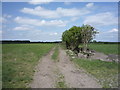
Farm track east of Anthorn
Off National Cycle Route 72.
Image: © JThomas
Taken: 28 May 2016
0.22 miles