IMAGES TAKEN NEAR TO
Bowness-on-Solway, WIGTON, CA7 5AE
Introduction
This page details the photographs taken nearby to CA7 5AE by members of the Geograph project.
The Geograph project started in 2005 with the aim of publishing, organising and preserving representative images for every square kilometre of Great Britain, Ireland and the Isle of Man.

There are currently over 7.5m images from over14,400 individuals and you can help contribute to the project by visiting https://www.geograph.org.uk
Image Map
Images are licensed for reuse under creativecommons.org/licenses/by-sa/2.0
Notes
- Clicking on the map will re-center to the selected point.
- The higher the marker number, the further away the image location is from the centre of the postcode.
Image Listing (6 Images Found)
Images are licensed for reuse under creativecommons.org/licenses/by-sa/2.0
Image
Details
Distance
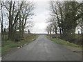
1
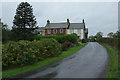
Bowness Hall
Farmhouse on the lane south of Bowness on Solway, seen here on a wet morning.
Image: © Stephen McKay
Taken: 6 Oct 2014
0.01 miles
2
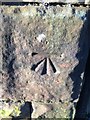
OS Cut Mark, Bowness-on-Solway, Bowness Hall
Easily spotted on farm building.
Image: © thejackrustles
Taken: 7 Feb 2020
0.02 miles
3
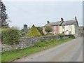
Bowness Hall Farm
Early 19th century Grade 2 listed building. Some fine examples of topiary in the garden.
Image: © Oliver Dixon
Taken: 9 Apr 2017
0.03 miles
6
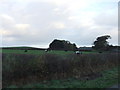
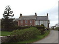
Bowness Hall
A white Trig pillar sits at the top of the hump behind the farm
Image: © David Brown
Taken: 24 Oct 2014
0.12 miles