IMAGES TAKEN NEAR TO
Kelsick, Abbeytown, WIGTON, CA7 4TL
Introduction
This page details the photographs taken nearby to CA7 4TL by members of the Geograph project.
The Geograph project started in 2005 with the aim of publishing, organising and preserving representative images for every square kilometre of Great Britain, Ireland and the Isle of Man.

There are currently over 7.5m images from over14,400 individuals and you can help contribute to the project by visiting https://www.geograph.org.uk
Image Map
Images are licensed for reuse under creativecommons.org/licenses/by-sa/2.0
Notes
- Clicking on the map will re-center to the selected point.
- The higher the marker number, the further away the image location is from the centre of the postcode.
Image Listing (4 Images Found)
Images are licensed for reuse under creativecommons.org/licenses/by-sa/2.0
Image
Details
Distance

2
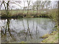
Pond at Kelsick
Kelsick consists of three farms plus this small, overgrown pond.
Image: © Bob Jenkins
Taken: 20 Mar 2006
0.06 miles
3
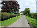
"Main Street", Kelsick
This is the centre of Kelsick. It hardly qualifies as a village; two or three farms, and very little else. It is cases such as this that present problems when completing the 'Geographical Context' boxes.
Image: © David Purchase
Taken: 29 Jul 2012
0.08 miles
4
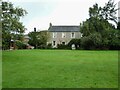
Kelsick House
An historic property in the hamlet
Image: © Kevin Waterhouse
Taken: 23 Aug 2023
0.10 miles