IMAGES TAKEN NEAR TO
Abbeytown, WIGTON, CA7 4RJ
Introduction
This page details the photographs taken nearby to CA7 4RJ by members of the Geograph project.
The Geograph project started in 2005 with the aim of publishing, organising and preserving representative images for every square kilometre of Great Britain, Ireland and the Isle of Man.

There are currently over 7.5m images from over14,400 individuals and you can help contribute to the project by visiting https://www.geograph.org.uk
Image Map
Images are licensed for reuse under creativecommons.org/licenses/by-sa/2.0
Notes
- Clicking on the map will re-center to the selected point.
- The higher the marker number, the further away the image location is from the centre of the postcode.
Image Listing (71 Images Found)
Images are licensed for reuse under creativecommons.org/licenses/by-sa/2.0
Image
Details
Distance
1
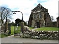
St Mary's Church, Abbeytown
The present church has been formed from Holm Cultram Abbey, a Cistercian monastery that had been founded in 1150. Now an Anglican Church, there have been several alterations and restorations since the Dissolution of the Monasteries in 1538. The church is a Grade I Listed Building. https://www.britishlistedbuildings.co.uk/101144608-church-of-st-mary-holme-abbey#.WqhQQjFLGtU
Image: © G Laird
Taken: 13 Mar 2018
0.06 miles
2
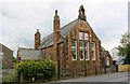
The Old School, Main Street
There is an Ordnance Survey flush bracket benchmark Image on the left hand side of the former C of E school at its front corner
Image: © Luke Shaw
Taken: 3 Aug 2019
0.07 miles
3
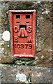
Benchmark on The Old School
Ordnance Survey flush bracket (serial number 10979) benchmark described on the Bench Mark Database at www.bench-marks.org.uk/bm110404
Image: © Luke Shaw
Taken: 3 Aug 2019
0.07 miles
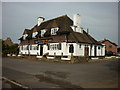
4
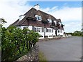
"The Wheatsheaf", Abbeytown
Currently sadly closed, like so many country pubs, but still in a very presentable condition and looking for new owners. A more recent visitor (May 2014) reported that it is now open for business.
Image: © Oliver Dixon
Taken: 2 Jun 2013
0.08 miles
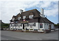
5

The Wheatsheaf Inn, Abbeytown - January 2017 (1)
Designed by Harry Redfern and built by Laings, The Wheatsheaf Inn opened on 16 December 1935 and replaced the Joiners' Arms, the Bush Inn and an earlier "Wheatsheaf", which had already been closed by the State Management Scheme. Released to private ownership in 1973, The Wheatsheaf Inn has had a chequered career in recent years with periods of closure, but is presently open for business.
See also: Image] .
For a 2013 view, see: Image] .
Photograph is for record only - I have no connection with this business and cannot advise on its products or services.
Image: © The Carlisle Kid
Taken: 5 Jan 2017
0.09 miles
8
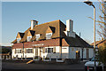
The Wheatsheaf Inn, Abbeytown - January 2017 (2)
Image: © The Carlisle Kid
Taken: 5 Jan 2017
0.09 miles
9
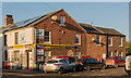
Harrisons Store - Abbeytown - January 2017
The Abbeytown village store - which looks the best place to obtain bagged coal and animal feed!
Photograph is for record only - I have no connection with this business and cannot advise on its products or services.
Image: © The Carlisle Kid
Taken: 5 Jan 2017
0.09 miles
10
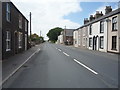
Main Street, Abbeytown (B5302)
Looking west.
Image: © JThomas
Taken: 18 Jun 2016
0.10 miles