IMAGES TAKEN NEAR TO
Skinburness Road, WIGTON, CA7 4QF
Introduction
This page details the photographs taken nearby to Skinburness Road, CA7 4QF by members of the Geograph project.
The Geograph project started in 2005 with the aim of publishing, organising and preserving representative images for every square kilometre of Great Britain, Ireland and the Isle of Man.

There are currently over 7.5m images from over14,400 individuals and you can help contribute to the project by visiting https://www.geograph.org.uk
Image Map
Images are licensed for reuse under creativecommons.org/licenses/by-sa/2.0
Notes
- Clicking on the map will re-center to the selected point.
- The higher the marker number, the further away the image location is from the centre of the postcode.
Image Listing (13 Images Found)
Images are licensed for reuse under creativecommons.org/licenses/by-sa/2.0
Image
Details
Distance
1
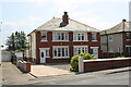
Nos. 50 (Brennach) and 48 Skinburness Road
There is an Ordnance Survey benchmark Image on the side of the left hand house near its front corner
Image: © Luke Shaw
Taken: 16 Jul 2019
0.00 miles
2
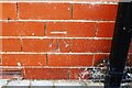
Benchmark on No. 50 Skinburness Road
Ordnance Survey cut mark benchmark levelled at 8.580m above Newlyn Datum verified in 1971
Image: © Luke Shaw
Taken: 16 Jul 2019
0.00 miles
3
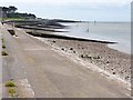
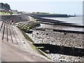
Silloth promenade
Sea wall, groynes and a shingle beach.
Image: © Oliver Dixon
Taken: 2 Jun 2013
0.08 miles
4
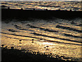
.Sundown at Silloth
The narrow beach running north from Silloth Docks to Skinburness is an excellent location for watching waders like these oystercatchers
Image: © Nigel Monckton
Taken: 18 Feb 2005
0.11 miles
5
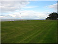
Park beside the shore, Silloth
Looking across the Solway Firth to Scotland.
Image: © David Purchase
Taken: 13 Oct 2016
0.12 miles
6
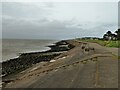
Terraced sea defences
With groynes into the sea
Image: © Kevin Waterhouse
Taken: 21 Aug 2023
0.14 miles
7
Sea wall
Looking south west from East Cote Light House towards Silloth
Image: © Alexander P Kapp
Taken: 25 Jun 2006
0.17 miles
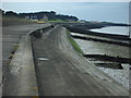
8
Silloth sea front
Sea wall, beach and groynes.
Image: © Oliver Dixon
Taken: 2 Jun 2013
0.18 miles
9
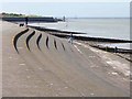
Sea wall at Silloth
Graceful curves and steps in the sea wall.
Image: © Oliver Dixon
Taken: 2 Jun 2013
0.21 miles
10

Benchmark on wall fronting No. 6 Criffel Street (Alma Terrace)
Ordnance Survey cut mark benchmark levelled at 10.604m above Newlyn Datum and verified in 1971
Image: © Luke Shaw
Taken: 16 Jul 2019
0.23 miles