IMAGES TAKEN NEAR TO
Silloth, WIGTON, CA7 4PS
Introduction
This page details the photographs taken nearby to CA7 4PS by members of the Geograph project.
The Geograph project started in 2005 with the aim of publishing, organising and preserving representative images for every square kilometre of Great Britain, Ireland and the Isle of Man.

There are currently over 7.5m images from over14,400 individuals and you can help contribute to the project by visiting https://www.geograph.org.uk
Image Map
Images are licensed for reuse under creativecommons.org/licenses/by-sa/2.0
Notes
- Clicking on the map will re-center to the selected point.
- The higher the marker number, the further away the image location is from the centre of the postcode.
Image Listing (10 Images Found)
Images are licensed for reuse under creativecommons.org/licenses/by-sa/2.0
Image
Details
Distance
2
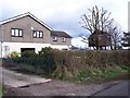
Winding Banks Tree House.
Now that's what you call a tree house complete with glazed windows.
Image: © John Holmes
Taken: 3 Apr 2006
0.08 miles
3
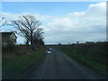
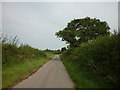
National Cycle Route 72
Heading north west towards Silloth.
Image: © JThomas
Taken: 18 Jun 2016
0.13 miles
4
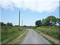
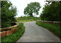
Minor road to Border
East and West Border are at the road end, in Image
Image: © David Purchase
Taken: 2 Oct 2018
0.14 miles
6
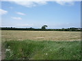
Grassland north west of Abbeytown
Recently cut.
Image: © JThomas
Taken: 18 Jun 2016
0.17 miles
8
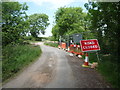
Road closure at Rumbling Bridge
National Cycle Route 72.
Image: © JThomas
Taken: 18 Jun 2016
0.19 miles
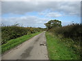
10
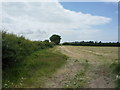
Grassland and hedgerow
North west of Abbeytown.
Image: © JThomas
Taken: 18 Jun 2016
0.22 miles