IMAGES TAKEN NEAR TO
Blackdyke, Silloth, WIGTON, CA7 4PL
Introduction
This page details the photographs taken nearby to CA7 4PL by members of the Geograph project.
The Geograph project started in 2005 with the aim of publishing, organising and preserving representative images for every square kilometre of Great Britain, Ireland and the Isle of Man.

There are currently over 7.5m images from over14,400 individuals and you can help contribute to the project by visiting https://www.geograph.org.uk
Image Map
Images are licensed for reuse under creativecommons.org/licenses/by-sa/2.0
Notes
- Clicking on the map will re-center to the selected point.
- The higher the marker number, the further away the image location is from the centre of the postcode.
Image Listing (8 Images Found)
Images are licensed for reuse under creativecommons.org/licenses/by-sa/2.0
Image
Details
Distance
2
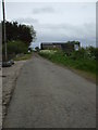
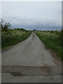
Cracked tarmac in Blackdyke
This road passes through Middle Farm, which has buildings on both sides.
Image: © Matthew Hatton
Taken: 24 May 2014
0.09 miles
4
Lane from Blackdyke
Shown as a track with green blobs on, I didn't see any when I drove up it!
Image: © Matthew Hatton
Taken: 24 May 2014
0.14 miles
5
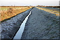
Drain
These drains are a major feature in this area
Image: © Bob Jenkins
Taken: 28 Dec 2005
0.18 miles