IMAGES TAKEN NEAR TO
The Lido Village, Barracks Bridge, WIGTON, CA7 4NN
Introduction
This page details the photographs taken nearby to The Lido Village, Barracks Bridge, CA7 4NN by members of the Geograph project.
The Geograph project started in 2005 with the aim of publishing, organising and preserving representative images for every square kilometre of Great Britain, Ireland and the Isle of Man.

There are currently over 7.5m images from over14,400 individuals and you can help contribute to the project by visiting https://www.geograph.org.uk
Image Map
Images are licensed for reuse under creativecommons.org/licenses/by-sa/2.0
Notes
- Clicking on the map will re-center to the selected point.
- The higher the marker number, the further away the image location is from the centre of the postcode.
Image Listing (11 Images Found)
Images are licensed for reuse under creativecommons.org/licenses/by-sa/2.0
Image
Details
Distance
2
Elizabeth II postbox, Barracks Bridge
Postbox No. CA7 342.
See Image] for close up.
Image: © JThomas
Taken: 18 Jun 2016
0.08 miles
3
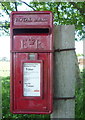
Close up, Elizabeth II postbox, Barracks Bridge
Postbox No. CA7 342.
See Image] for wider view.
Image: © JThomas
Taken: 18 Jun 2016
0.08 miles
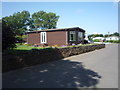
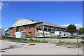
6
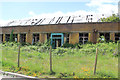
Former Mess building
Former officer's mess, RAF Silloth.
Image: © Phill
Taken: 31 May 2015
0.15 miles
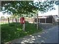
7

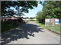
Building at entrance to former airfield
This appears to be a former RAF guard house.
Image: © Kevin Waterhouse
Taken: 21 Aug 2023
0.17 miles
9
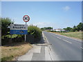
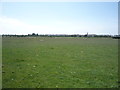
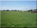
Entering Silloth
Heading north west on the B5302.
Image: © JThomas
Taken: 18 Jun 2016
0.21 miles