IMAGES TAKEN NEAR TO
Pelutho, Silloth, WIGTON, CA7 4LT
Introduction
This page details the photographs taken nearby to CA7 4LT by members of the Geograph project.
The Geograph project started in 2005 with the aim of publishing, organising and preserving representative images for every square kilometre of Great Britain, Ireland and the Isle of Man.

There are currently over 7.5m images from over14,400 individuals and you can help contribute to the project by visiting https://www.geograph.org.uk
Image Map
Images are licensed for reuse under creativecommons.org/licenses/by-sa/2.0
Notes
- Clicking on the map will re-center to the selected point.
- The higher the marker number, the further away the image location is from the centre of the postcode.
Image Listing (13 Images Found)
Images are licensed for reuse under creativecommons.org/licenses/by-sa/2.0
Image
Details
Distance
1
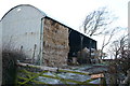
Barn, Pelutho
A more traditional hay barn - less often seen due to use of silage
Image: © Bob Jenkins
Taken: 28 Dec 2005
0.10 miles
5
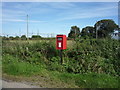
Elizabeth II postbox on the B5301, Pelutho
Image: © JThomas
Taken: 17 Sep 2016
0.15 miles
6
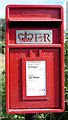
Close up, Elizabeth II postbox on the B5301, Pelutho
Postbox No. CA7 368.
See Image] for wider view.
Image: © JThomas
Taken: 17 Sep 2016
0.15 miles
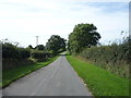
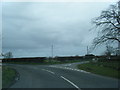
7
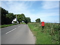
B5301, Pelutho
Looking north showing position of Postbox No. CA7 368.
See Image] for postbox.
Image: © JThomas
Taken: 17 Sep 2016
0.15 miles
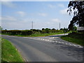
8
Road junction, Pelutho
Minor road with the B5301.
Image: © JThomas
Taken: 17 Sep 2016
0.16 miles
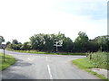
10
B5301
Road junction on the B5301 at Pelutho
Image: © Alexander P Kapp
Taken: 6 Jun 2007
0.16 miles