IMAGES TAKEN NEAR TO
Silloth, WIGTON, CA7 4LL
Introduction
This page details the photographs taken nearby to CA7 4LL by members of the Geograph project.
The Geograph project started in 2005 with the aim of publishing, organising and preserving representative images for every square kilometre of Great Britain, Ireland and the Isle of Man.

There are currently over 7.5m images from over14,400 individuals and you can help contribute to the project by visiting https://www.geograph.org.uk
Image Map (Loading...)


Getting Data...Please wait
Leaflet Map data © OpenStreetMap
Images are licensed for reuse under creativecommons.org/licenses/by-sa/2.0
Notes
- Clicking on the map will re-center to the selected point.
- The higher the marker number, the further away the image location is from the centre of the postcode.
Image Listing (5 Images Found)
Images are licensed for reuse under creativecommons.org/licenses/by-sa/2.0
Image
Details
Distance
1

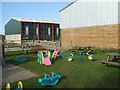
Gincase Farm Park, Mawbray Hayrigg
He thought he was going to get some food off me! Great day out for the kids
Image: © John Gibson
Taken: 30 Aug 2005
0.03 miles
3
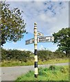
Direction Sign – Signpost near Mawbray Hayrigg
Located on the southeast side of the junction at Mawbray Hayrigg. Holme St. Cuthbert parish. 3 arms and pawn finial.
Milestone Society National ID: CU_NY0949A
Image: © B Todd
Taken: 12 Sep 2023
0.05 miles
5
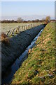
Drainage ditch
One of many in this draining this ex-marsh
Image: © Bob Jenkins
Taken: 28 Dec 2005
0.17 miles