IMAGES TAKEN NEAR TO
Beckfoot, Silloth, WIGTON, CA7 4LB
Introduction
This page details the photographs taken nearby to CA7 4LB by members of the Geograph project.
The Geograph project started in 2005 with the aim of publishing, organising and preserving representative images for every square kilometre of Great Britain, Ireland and the Isle of Man.

There are currently over 7.5m images from over14,400 individuals and you can help contribute to the project by visiting https://www.geograph.org.uk
Image Map
Images are licensed for reuse under creativecommons.org/licenses/by-sa/2.0
Notes
- Clicking on the map will re-center to the selected point.
- The higher the marker number, the further away the image location is from the centre of the postcode.
Image Listing (21 Images Found)
Images are licensed for reuse under creativecommons.org/licenses/by-sa/2.0
Image
Details
Distance
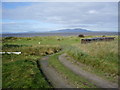
1
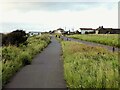
Cycle lane approaching Beckfoot Bridge
Image: © Kevin Waterhouse
Taken: 22 Aug 2023
0.10 miles
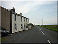
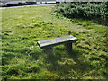
4
Beckfoot Burial Ground
The sign at the entrance extols the natural and wildlife of this Quaker Burial Ground http://www.solwaycoastaonb.org.uk/beckfoot.php
Image: © Alexander P Kapp
Taken: 26 Sep 2007
0.11 miles
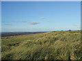
5
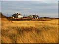
Dunes, Beckfoot, Holme St Cuthbert
The marram grass caught in evening sunlight.
Image: © Andrew Smith
Taken: 4 Apr 2015
0.11 miles
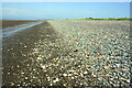

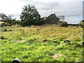
10
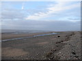
Beckfoot
A view looking northeast along the beach near Beckfoot. This is part of the Allerdale Ramble and also the Cumbria Coast Way.
Image: © Phil Williams
Taken: 14 Feb 2006
0.16 miles