IMAGES TAKEN NEAR TO
Blitterlees, Silloth, WIGTON, CA7 4JN
Introduction
This page details the photographs taken nearby to CA7 4JN by members of the Geograph project.
The Geograph project started in 2005 with the aim of publishing, organising and preserving representative images for every square kilometre of Great Britain, Ireland and the Isle of Man.

There are currently over 7.5m images from over14,400 individuals and you can help contribute to the project by visiting https://www.geograph.org.uk
Image Map
Images are licensed for reuse under creativecommons.org/licenses/by-sa/2.0
Notes
- Clicking on the map will re-center to the selected point.
- The higher the marker number, the further away the image location is from the centre of the postcode.
Image Listing (4 Images Found)
Images are licensed for reuse under creativecommons.org/licenses/by-sa/2.0
Image
Details
Distance
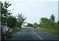
1
The B5300 heading through Blitterlees in Cumbria
Image: © James Denham
Taken: 3 Jul 2010
0.04 miles
2
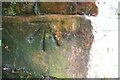
Benchmark on building at Blitterlees Farm
Ordnance Survey cut mark benchmark levelled at 9.048m above Newlyn Datum in 1961
Image: © Luke Shaw
Taken: 16 Jul 2019
0.06 miles
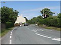
3
Blitterness Farm on SE side of B5300
There is an Ordnance Survey benchmark Image hidden behind a bush on the near corner of the barn in the middle of the image
Image: © Luke Shaw
Taken: 16 Jul 2019
0.07 miles