IMAGES TAKEN NEAR TO
Alma Terrace, WIGTON, CA7 4DS
Introduction
This page details the photographs taken nearby to Alma Terrace, CA7 4DS by members of the Geograph project.
The Geograph project started in 2005 with the aim of publishing, organising and preserving representative images for every square kilometre of Great Britain, Ireland and the Isle of Man.

There are currently over 7.5m images from over14,400 individuals and you can help contribute to the project by visiting https://www.geograph.org.uk
Image Map
Images are licensed for reuse under creativecommons.org/licenses/by-sa/2.0
Notes
- Clicking on the map will re-center to the selected point.
- The higher the marker number, the further away the image location is from the centre of the postcode.
Image Listing (134 Images Found)
Images are licensed for reuse under creativecommons.org/licenses/by-sa/2.0
Image
Details
Distance
1
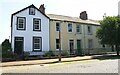
Houses of Alma Terrace, Criffel Street
There is an Ordnance Survey benchmark Image on the stone in the roadside wall left of the left hand house's gate.
Image: © Luke Shaw
Taken: 16 Jul 2019
0.00 miles
2
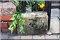
Benchmark on wall fronting No. 6 Criffel Street (Alma Terrace)
Ordnance Survey cut mark benchmark levelled at 10.604m above Newlyn Datum and verified in 1971
Image: © Luke Shaw
Taken: 16 Jul 2019
0.01 miles
4
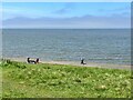
The Solway Firth at Silloth
People are enjoying spring sunshine on Silloth Promenade; the Scottish coast on the far side of The Solway Firth is hidden in the mist.
Image: © Adrian Taylor
Taken: 7 May 2023
0.08 miles
5
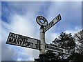
Old Signpost in Silloth
Situated on the Green just off Criffel Street.
Image: © Jennifer Petrie
Taken: 18 Nov 2022
0.09 miles
6
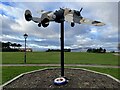
Model Lockheed Hudson Bomber in Silloth
This new feature on the Green was unveiled in April 2018 to celebrate the 100th birthday of the RAF and also to celebrate the town’s involvement in WWII. Silloth Airfield had opened in 1939 and closed in 1960. This airfield had twin responsibilities, the maintenance and repair of planes for use in WWII and the training of aircrews.
Tragically a large number of Lockheed Hudson aircraft and their crews crashed during take off or approach to Silloth airfield and were lost in the Solway. Hence it was known locally as Hudson Bay.
The Lockheed Hudson was a light American bomber used for coastal reconnaissance.
Just across the road is Silloth RAFA Club, the only remaining RAFA Club in Cumbria.
Image: © Jennifer Petrie
Taken: 18 Nov 2022
0.09 miles
7
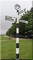
Old Direction Sign - Signpost by the B5302, Criffel Street, Silloth
Annulus finial - 3 arms; Cumberland named halo by the B5302, in parish of Silloth-on-Solway (Allerdale District), Silloth, junction of Criffel Street, Petteril Street and Skinburness Road, on lawn.
To be surveyed
Milestone Society National ID: CU_NY1153
Image: © M Hatton
Taken: 26 Jun 2017
0.09 miles
8
Wastewater Pumping Station
On the sea front
Image: © Kevin Waterhouse
Taken: 21 Aug 2023
0.09 miles
9
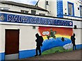
RAFA Club, Petteril Street, Silloth
This is the only remaining RAFA Club in Cumbria.
Image: © Jennifer Petrie
Taken: 18 Nov 2022
0.09 miles
10
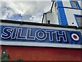
Silloth RAFA Club
This is the only remaining RAFA Club in Cumbria. Situated in Petteril Street opposite the Green in Silloth.
Image: © Jennifer Petrie
Taken: 18 Nov 2022
0.09 miles