IMAGES TAKEN NEAR TO
Wampool Street, WIGTON, CA7 4BS
Introduction
This page details the photographs taken nearby to Wampool Street, CA7 4BS by members of the Geograph project.
The Geograph project started in 2005 with the aim of publishing, organising and preserving representative images for every square kilometre of Great Britain, Ireland and the Isle of Man.

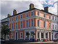
There are currently over 7.5m images from over14,400 individuals and you can help contribute to the project by visiting https://www.geograph.org.uk
Image Map
Images are licensed for reuse under creativecommons.org/licenses/by-sa/2.0
Notes
- Clicking on the map will re-center to the selected point.
- The higher the marker number, the further away the image location is from the centre of the postcode.
Image Listing (245 Images Found)
Images are licensed for reuse under creativecommons.org/licenses/by-sa/2.0
Image
Details
Distance
1
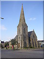
Christ Church, Solway
Christ Church was built of sandstone and Irish granite in 1870-1. Quite a large church, with nave and aisles, an apse, and a NW porch steeple with broach-spire. Inside all is brick-faced, yellow bricks with red-brick trim and also bands of brick projecting and recessed.
Image: © Humphrey Bolton
Taken: 13 Jun 2003
0.01 miles
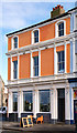
2
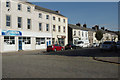
Wampool Street, Silloth
Seen from Criffel Street, one of Silloth's broad cobbled streets leading back from the sea. The Blue Dolphin Cafe occupies the ground floor of the building on the corner, serving the needs of visitors to this Victorian resort.
Image: © Stephen McKay
Taken: 2 Oct 2014
0.01 miles
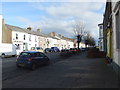
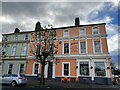
4
Houses and businesses facing Silloth Green
An assortment of businesses and homes face on Criffel Street face onto Silloth Green. Christ Church can be seen to the left of the terrace containing shops and houses.
Image: © Graham Robson
Taken: 13 Jul 2012
0.02 miles
5
Former "Criffel" pub, Silloth - October 2017 (1)
Situated on the corner of Esk Street and Criffel Street, the building probably dates from the late 19th Century when Silloth expanded following arrival of the railway. The pub was State Managed from 1916 (exact date yet to be ascertained) until sold to Greenall Whitley on 24 May 1973. Date of closure as a pub in currently unclear, but the ground floor is now a café with offices above.
Graham Robson photographed the pub in July 2012, when still closed. See: Image] .
See also: Image] .
Photographs are for record only - I have no involvement with any business seen in this view and cannot advise on their products or services.
Image: © The Carlisle Kid
Taken: 5 Oct 2017
0.02 miles
6
Former "Criffel" pub, Silloth - October 2017 (2)
The Criffel Street face of the former "Criffel" pub. For information on this building, see: Image] .
Image: © The Carlisle Kid
Taken: 5 Oct 2017
0.02 miles
7
Mrs Wilson?s Coffee House and Eaterie in Silloth
Situated in Criffel Street, the Main Street of Silloth, with the Green opposite.
Mrs Wilson was the married name of Kathleen Ferrier CBE 1912-1953, the famous singer. She shot to fame while living in Silloth and performing in Cumberland.
Image: © Jennifer Petrie
Taken: 18 Nov 2022
0.02 miles
8
Mrs Wilson?s Coffee House in Criffel Street Silloth
This attractive building is situated in the Main Street overlooking the Green. Mrs Wilson was the married name of Kathleen Ferrier 1912-1953 the famous singer. She shot to fame while staying in Silloth and performing nearby.
Image: © Jennifer Petrie
Taken: 18 Nov 2022
0.02 miles
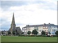
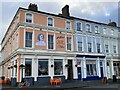
9

The Balmoral Hotel, Silloth
At the corner of Wampool Street (left) and Criffel Street. The town of Silloth was developed in Victorian times, the wide tree-lined streets were surfaced with granite setts, which are retained here in Criffel Street (also in Eden Street http://www.geograph.org.uk/photo/2169042 ).
Image: © Rose and Trev Clough
Taken: 9 Aug 2009
0.02 miles
10
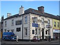
The Balmoral Hotel, Silloth
The pub is located on the corner of Criffel Street and Wampool Street.
Image: © Graham Robson
Taken: 13 Jul 2012
0.02 miles