IMAGES TAKEN NEAR TO
Station Road, WIGTON, CA7 4BL
Introduction
This page details the photographs taken nearby to Station Road, CA7 4BL by members of the Geograph project.
The Geograph project started in 2005 with the aim of publishing, organising and preserving representative images for every square kilometre of Great Britain, Ireland and the Isle of Man.

There are currently over 7.5m images from over14,400 individuals and you can help contribute to the project by visiting https://www.geograph.org.uk
Image Map
Images are licensed for reuse under creativecommons.org/licenses/by-sa/2.0
Notes
- Clicking on the map will re-center to the selected point.
- The higher the marker number, the further away the image location is from the centre of the postcode.
Image Listing (117 Images Found)
Images are licensed for reuse under creativecommons.org/licenses/by-sa/2.0
Image
Details
Distance
1

Clubhouse, Silloth on Solway Golf Club
The club was founded in 1892, the clubhouse dates from 1903. The scenic links course is laid out on sandhills to the southwest. Club website : http://www.sillothgolfclub.co.uk/ .
Image: © Rose and Trev Clough
Taken: 9 Aug 2009
0.00 miles
2
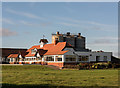
Silloth Golf Club - October 2017
The clubhouse of the David Grant designed Silloth Golf Club, which opened in 1892.
Photograph is for record only - I have no connection with this club and all queries should be directed through the club web site at: https://www.sillothgolfclub.co.uk/
Image: © The Carlisle Kid
Taken: 27 Oct 2017
0.00 miles
3

Vulcan bomber over Silloth
The only Avro Vulcan bomber still flying made a couple of sweeps over the docks - in this zoom shot, the Vulcan is over the golf clubhouse. For more information on the aircraft, see http://www.vulcantothesky.org/ .
A grounded example of the Vulcan is on display at the Solway Aviation Museum, Carlisle Airport http://www.geograph.org.uk/photo/73364 .
Image: © Rose and Trev Clough
Taken: 9 Aug 2009
0.02 miles
4
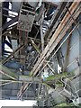
Inside silo shed, Silloth Dock
Apparently disused - for exterior view and information, see Image .
Image: © Rose and Trev Clough
Taken: 9 Aug 2009
0.05 miles
5
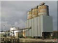
Rusting storage silos, Port of Silloth
A range of rusting storage silos at the Port of Silloth with what appear to be more modern storage tanks visible behind.
Image: © Graham Robson
Taken: 15 Jul 2012
0.05 miles
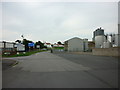
6
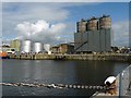
Storage facilities at Silloth Dock
The silver coloured tanks on the left are used to store molasses, imported for animal feed production http://www.primemolasses.com/distribution.asp . The three silos on the right were installed in 1983 to store cement powder prior to export, but the trade ceased in 2002 (for inside view, see http://www.geograph.org.uk/photo/2169030 ).
Other commodities handled at the port include fertilizer, wheat and wood pulp. For more information, see : "The Port of Silloth, 1859-2009" by Capt. Chris Puxley, 2009 http://www.coastalshipping.co.uk/Publications.htm .
Image: © Rose and Trev Clough
Taken: 9 Aug 2009
0.07 miles
8
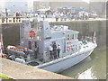
HMS Biter at Silloth inner harbour
A visit from a Royal Navy vessel, the HMS Biter, to Silloth Harbour.
Image: © Renata Edge
Taken: 20 Mar 2005
0.07 miles
9
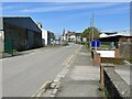
Station Road, Silloth
This nondescript part of Station Road road serves the south side of Silloth docks and Silloth Golf Club, continuing to the sea shore and the Silloth Nursing and Residential Care Home. It is the route of the England Coast Path.
Several sets of railway track formerly crossed this stretch of road between Silloth goods yard and the docks to the left. Station Road Industrial Estate on the right now occupies part of the site of the goods yard.
Silloth town centre is in the background with the spire of Christ Church prominent.
Image: © Adrian Taylor
Taken: 7 May 2023
0.08 miles
10
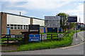
A Forest of Signs
The signs give a hint of the industrial quarter at the south end of Silloth.
Image: © Anne Burgess
Taken: 7 May 2018
0.09 miles