IMAGES TAKEN NEAR TO
Gowrie, WIGTON, CA7 3PZ
Introduction
This page details the photographs taken nearby to Gowrie, CA7 3PZ by members of the Geograph project.
The Geograph project started in 2005 with the aim of publishing, organising and preserving representative images for every square kilometre of Great Britain, Ireland and the Isle of Man.

There are currently over 7.5m images from over14,400 individuals and you can help contribute to the project by visiting https://www.geograph.org.uk
Image Map
Images are licensed for reuse under creativecommons.org/licenses/by-sa/2.0
Notes
- Clicking on the map will re-center to the selected point.
- The higher the marker number, the further away the image location is from the centre of the postcode.
Image Listing (5 Images Found)
Images are licensed for reuse under creativecommons.org/licenses/by-sa/2.0
Image
Details
Distance
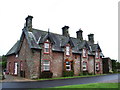
2
Cockgate, Gowrie, Baggrow
It's been painted!
Image: © Alexander P Kapp
Taken: 20 Sep 2007
0.02 miles
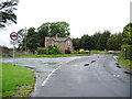
3
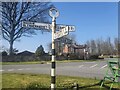
Direction Sign ? Signpost on the B5299 at Gowrie Cottages
Located on the southeast side of the staggered crossroads on the B5299 at Gowrie Cottages in Allhallows parish. 4 arms and annulus finial.
Milestone Society National ID: CU_NY1742
Image: © D Phillips
Taken: Unknown
0.03 miles
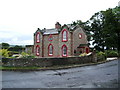
5
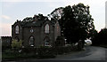
Cockgate, near Blennerhasset
A rather imposing house at the junction of two relatively minor roads between Blennerhasset and Aspatria.
Image: © Nigel Monckton
Taken: 3 Sep 2005
0.16 miles