IMAGES TAKEN NEAR TO
Westnewton, WIGTON, CA7 3PF
Introduction
This page details the photographs taken nearby to CA7 3PF by members of the Geograph project.
The Geograph project started in 2005 with the aim of publishing, organising and preserving representative images for every square kilometre of Great Britain, Ireland and the Isle of Man.

There are currently over 7.5m images from over14,400 individuals and you can help contribute to the project by visiting https://www.geograph.org.uk
Image Map
Images are licensed for reuse under creativecommons.org/licenses/by-sa/2.0
Notes
- Clicking on the map will re-center to the selected point.
- The higher the marker number, the further away the image location is from the centre of the postcode.
Image Listing (6 Images Found)
Images are licensed for reuse under creativecommons.org/licenses/by-sa/2.0
Image
Details
Distance
1
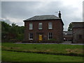
19thC Farmhouse in West Newton
Home Farm, West Newton. c.1860.
Image: © Matthew Hatton
Taken: 24 May 2014
0.22 miles
2
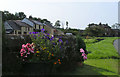
Village Scene, Westnewtown
Westnewton boasts that it is the winner of the Best Kept Small Village in Allerdale award.
Image: © Nigel Monckton
Taken: 11 Sep 2005
0.22 miles
3
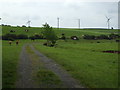
Access track to the West Newton sewage works
Cows showing some interest in a photographer leaning on their field gate.
Image: © Matthew Hatton
Taken: 24 May 2014
0.23 miles
4
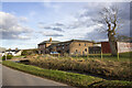
Converted vernacular farm buildings at Home Farm
Image: © P Gaskell
Taken: 1 Mar 2023
0.23 miles
5
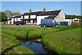
Ghyll Farm
House and barns stand beside the Westnewton Beck and one of its tributaries.
Image: © Anne Burgess
Taken: 7 May 2018
0.24 miles
6
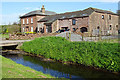
Home Farm
There's something irresistibly picturesque about a village green with a stream running through it. The buildings are the house and barns at Home Farm, and the stream is the Westnewton Beck.
Image: © Anne Burgess
Taken: 7 May 2018
0.24 miles