IMAGES TAKEN NEAR TO
The Guards, WIGTON, CA7 3PD
Introduction
This page details the photographs taken nearby to The Guards, CA7 3PD by members of the Geograph project.
The Geograph project started in 2005 with the aim of publishing, organising and preserving representative images for every square kilometre of Great Britain, Ireland and the Isle of Man.

There are currently over 7.5m images from over14,400 individuals and you can help contribute to the project by visiting https://www.geograph.org.uk
Image Map
Images are licensed for reuse under creativecommons.org/licenses/by-sa/2.0
Notes
- Clicking on the map will re-center to the selected point.
- The higher the marker number, the further away the image location is from the centre of the postcode.
Image Listing (15 Images Found)
Images are licensed for reuse under creativecommons.org/licenses/by-sa/2.0
Image
Details
Distance
1
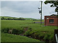
Lumps & Bumps
In the centre of this picture, to the left of the electric pole are the slight remains of the 'de Newtons Castle. It is most likely to have been made of earth & timber and was built around c.1130. It lasted until the reign of King Edward III when it was either abandoned or burnt by the Scots.
Image: © Matthew Hatton
Taken: 24 May 2014
0.04 miles
2
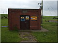
Westnewton Wastewater Pumping Station
The stone plaque above the door reads: WIGTON DISTRICT COUNCIL, WEST NEWTON SEWAGE WORKS, 1937-38, TAYLOR & WALLIN, CIVIL ENGINEERS, NEWCASTLE UPON TYNE.
Also found this info on the net: (Major William Wallin, a civil engineer & partner of the firm of Messrs. Taylor and Wallin, engineers. Newcastle, whoso home was Northumberland Avenue. Forest Hall, Newcastle. Died in a car crash on 22nd Sept 1934. "Yorkshire Evening Post")
Image: © Matthew Hatton
Taken: 24 May 2014
0.04 miles
3
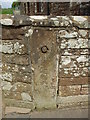
Beautifully simple
Herring-bone cut sandstone marker post in Westnewton.
Image: © Matthew Hatton
Taken: 24 May 2014
0.06 miles
4
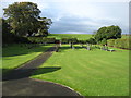
Westnewton cemetery
Clearly a fairly new cemetery, about 600 metres WSW of the church which is seen in Image
Image: © David Purchase
Taken: 13 Oct 2016
0.07 miles
5
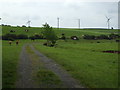
Access track to the West Newton sewage works
Cows showing some interest in a photographer leaning on their field gate.
Image: © Matthew Hatton
Taken: 24 May 2014
0.09 miles
6
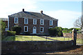
Fine House
West Newton Grange, mid 19thC with late 19thC extension. Grade II Listed. Painted
stucco with V-jointed quoins, under graduated greenslate roof with stucco
chimney stacks. 2 storeys, 3 bays with lower 3-bay extension and L-shaped
stables/barn to left. Panelled door with glazed overlight in Ionic porch. Sash
windows, those on ground floor under console-bracketed hoods and those above
with glazing bars. Extension has panelled door within stucco porch. Central
2-light bay window flanked by sash windows under console-bracketed hoods.
First-floor gabled dormer window. Stables/barn have plank door with flanking
casement windows.
Image: © Matthew Hatton
Taken: 24 May 2014
0.10 miles
7
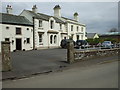
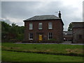
Westnewton Hall
This Georgian house is eyecatchingly elegant, and it and its wall and gateposts are Grade II Listed. See https://historicengland.org.uk/listing/the-list/list-entry/1217574 for more details.
Image: © Anne Burgess
Taken: 7 May 2018
0.11 miles
8
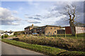
Converted vernacular farm buildings at Home Farm
Image: © P Gaskell
Taken: 1 Mar 2023
0.13 miles
9
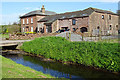
Home Farm
There's something irresistibly picturesque about a village green with a stream running through it. The buildings are the house and barns at Home Farm, and the stream is the Westnewton Beck.
Image: © Anne Burgess
Taken: 7 May 2018
0.13 miles
10
19thC Farmhouse in West Newton
Home Farm, West Newton. c.1860.
Image: © Matthew Hatton
Taken: 24 May 2014
0.13 miles