IMAGES TAKEN NEAR TO
Aspatria, WIGTON, CA7 3LB
Introduction
This page details the photographs taken nearby to CA7 3LB by members of the Geograph project.
The Geograph project started in 2005 with the aim of publishing, organising and preserving representative images for every square kilometre of Great Britain, Ireland and the Isle of Man.

There are currently over 7.5m images from over14,400 individuals and you can help contribute to the project by visiting https://www.geograph.org.uk
Image Map
Images are licensed for reuse under creativecommons.org/licenses/by-sa/2.0
Notes
- Clicking on the map will re-center to the selected point.
- The higher the marker number, the further away the image location is from the centre of the postcode.
Image Listing (10 Images Found)
Images are licensed for reuse under creativecommons.org/licenses/by-sa/2.0
Image
Details
Distance
1
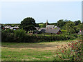
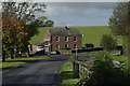
Westnewton
A view of the village from the B5301 which comes from Aspatria.
Image: © Nigel Monckton
Taken: 11 Sep 2005
0.10 miles
2
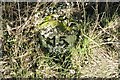
Old Milestone by the B5301, north east of Westnewton
Carved stone post by the B5301, in parish of WESTNEWTON (ALLERDALE District), South East of Newton Field, on grass verge, on West side of road. Wigton curved red stone, erected by the Cockermouth & Maryport turnpike trust in the 19th century.
Inscription reads:-
WORKINGTON
15
WIGTON
8
Carved benchmark.
Milestone Society National ID: CU_WGWO08.
Image: © CF Smith
Taken: 16 Sep 2005
0.15 miles
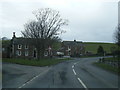
3
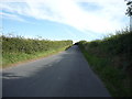
B5301 towards Westnewton
Heading south east.
Image: © JThomas
Taken: 17 Sep 2016
0.18 miles
5
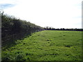
Eastern end of Westnewton
The B5301 Aspatria - Silloth road bends to the right here avoiding most of Westnewton village which lies along the road towards Allonby.
Image: © Stephen McKay
Taken: 6 Oct 2014
0.22 miles
7
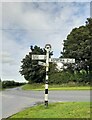
Direction Sign – Signpost on the B5301 east of Westnewton
Located on the south side of the junction on the B5301 at the east end of Westnewton. Westnewton parish. 3 arms and annulus finial. The Silloth, Wigton and Carlisle arm replaced separate arms to Carlisle 19 and B5301; Silloth 7 / Wigton 8, see http://www.geog.port.ac.uk/webmap/thelakes/photos/bpi26.jpg from 2008. Carlisle 19 is still visible on Street View in 2010.
Milestone Society National ID: CU_NY1344
Image: © B Todd
Taken: 12 Sep 2023
0.23 miles
8

Road junction, edge of Westnewton village
Image: © Rose and Trev Clough
Taken: 24 Apr 2011
0.23 miles
9
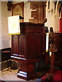
Interior of The Parish Church of St Matthew, Westnewton
Image: © Alexander P Kapp
Taken: 3 May 2007
0.24 miles
10

The Parish Church of St Matthew, Westnewton
Image: © Alexander P Kapp
Taken: 3 May 2007
0.24 miles