IMAGES TAKEN NEAR TO
Queen Street, WIGTON, CA7 3AS
Introduction
This page details the photographs taken nearby to Queen Street, CA7 3AS by members of the Geograph project.
The Geograph project started in 2005 with the aim of publishing, organising and preserving representative images for every square kilometre of Great Britain, Ireland and the Isle of Man.

There are currently over 7.5m images from over14,400 individuals and you can help contribute to the project by visiting https://www.geograph.org.uk
Image Map (Loading...)


Getting Data...Please wait
Leaflet Map data © OpenStreetMap
Images are licensed for reuse under creativecommons.org/licenses/by-sa/2.0
Notes
- Clicking on the map will re-center to the selected point.
- The higher the marker number, the further away the image location is from the centre of the postcode.
Image Listing (148 Images Found)
Images are licensed for reuse under creativecommons.org/licenses/by-sa/2.0
Image
Details
Distance
1
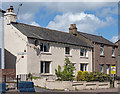
Former "Shoulder of Mutton" pub, Aspatria - October 2017
Local knowledge in the shape of historian Denis Irwin suggests this was the "Shoulder of Mutton" public house, acquired by the State Management Scheme in October 1918. While it appears on the 1925 OS Map, as a small one-room pub it was most likely closed shortly after purchase.
Now a private dwelling with no public access.
Image: © The Carlisle Kid
Taken: 27 Oct 2017
0.01 miles
2
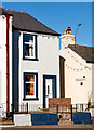
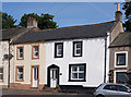
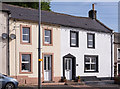
Private house on corner Brough Street and Queen Street, Aspatria - May 2017
This was initially thought to be "Shoulder of Mutton", but further research suggests that was the property to the immediate left and this was never anything more than a private dwelling.
Image: © The Carlisle Kid
Taken: 14 May 2017
0.02 miles
3
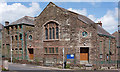
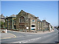
Methodist Church, Aspatria - May 2017
Dating from 1898, the Church is only open during times of worship.
Aspatria Methodist Church web site may be found: http://wigtonmethodistcircuit.co.uk/aspatria-methodist-church/ and any queries should be directed through this site.
Image: © The Carlisle Kid
Taken: 14 May 2017
0.03 miles
4
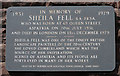
Sheila Fell Memorial - Aspatria - May 2017
On the wall of the Methodist Church, this plaque records the life of local artist Sheila Fell. Information on Ms Fell may be found on Wikipedia at: https://en.wikipedia.org/wiki/Sheila_Fell
Image: © The Carlisle Kid
Taken: 14 May 2017
0.03 miles
6
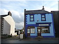
Fisher's Fryer, Queen Street, Aspatria
Recently painted blue. Buildings in this part of Cumbria are often painted in strong bright colours.
Image: © Christine Johnstone
Taken: 23 Oct 2014
0.05 miles
8
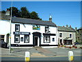
Former "Fox & Hounds", Aspatria - May 2017 (1)
Believed to be mid-19th Century former pub (also once known as the "Hare & Hounds"), it came under the State Management Scheme in November 1918. Returned to the private sector in 1973 when sold to Jennings Brothers Limited for £14,800, it seems to have closed circa 2007. A Planning Application dated January 2012 sought approval for conversion to two private dwellings, altering the premises to its current appearance.
See also: Image] .
For a pre-closure view see: Image] and http://www.geog.port.ac.uk/webmap/thelakes/html/lgaz/lk15323.htm
Image: © The Carlisle Kid
Taken: 31 May 2017
0.05 miles
9
Former "Fox & Hounds", Aspatria - May 2017 (2)
For information on this building, see: Image] .
Image: © The Carlisle Kid
Taken: 31 May 2017
0.05 miles
10
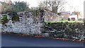
Walls on SW side of North Road outside St Kentigern's churchyard
There is an Ordnance Survey benchmark Image on the left hand side of the junction of the walls with gravestones visible behind the right hand wall
Image: © Roger Templeman
Taken: 10 Nov 2023
0.08 miles