IMAGES TAKEN NEAR TO
Arkleby, WIGTON, CA7 2DT
Introduction
This page details the photographs taken nearby to CA7 2DT by members of the Geograph project.
The Geograph project started in 2005 with the aim of publishing, organising and preserving representative images for every square kilometre of Great Britain, Ireland and the Isle of Man.

There are currently over 7.5m images from over14,400 individuals and you can help contribute to the project by visiting https://www.geograph.org.uk
Image Map
Images are licensed for reuse under creativecommons.org/licenses/by-sa/2.0
Notes
- Clicking on the map will re-center to the selected point.
- The higher the marker number, the further away the image location is from the centre of the postcode.
Image Listing (7 Images Found)
Images are licensed for reuse under creativecommons.org/licenses/by-sa/2.0
Image
Details
Distance
2
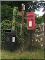
Postbox and signs at Wardhall Cottages
A Queen Elizabeth II postbox beside a pair of signposts and a bin at Wardhall Cottages.
Image: © Graham Robson
Taken: 17 Jun 2016
0.12 miles
3
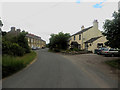
Wardhall Cottages
Wardhall Cottages, a couple of short rows of houses either side of the road between Gilcrux and Parsonby.
Image: © Graham Robson
Taken: 17 Jun 2016
0.13 miles
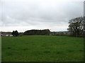
5
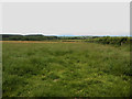
Grassfield west of Grange Farm
A field of grass to the west of Grange Farm.
Image: © Graham Robson
Taken: 17 Jun 2016
0.16 miles
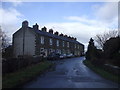
6
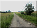
Track north of Eweclose farm
The track which connects Eweclose farm with the outside world.
Image: © Graham Robson
Taken: 17 Jun 2016
0.22 miles
7
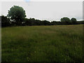
Grass fields at Eweclose farm
Grass fields at Eweclose farm between the farm steading and the country road to the north.
Image: © Graham Robson
Taken: 17 Jun 2016
0.23 miles