IMAGES TAKEN NEAR TO
Parsonby, Aspatria, WIGTON, CA7 2DL
Introduction
This page details the photographs taken nearby to CA7 2DL by members of the Geograph project.
The Geograph project started in 2005 with the aim of publishing, organising and preserving representative images for every square kilometre of Great Britain, Ireland and the Isle of Man.

There are currently over 7.5m images from over14,400 individuals and you can help contribute to the project by visiting https://www.geograph.org.uk
Image Map
Images are licensed for reuse under creativecommons.org/licenses/by-sa/2.0
Notes
- Clicking on the map will re-center to the selected point.
- The higher the marker number, the further away the image location is from the centre of the postcode.
Image Listing (12 Images Found)
Images are licensed for reuse under creativecommons.org/licenses/by-sa/2.0
Image
Details
Distance
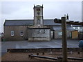
5
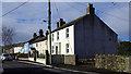
Plumbland
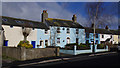
West House Farm and adjoining terrace of houses.
Image: © Ian Taylor
Taken: 13 Mar 2019
0.18 miles
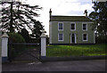
9
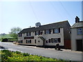
Plumbland
A terrace of houses adjoining West House Farm.
Image: © Ian Taylor
Taken: 13 Mar 2019
0.21 miles
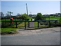
10
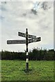
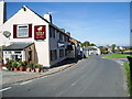
Direction Sign – Signpost west of Plumbland
Located on the southeast side of the crossroads on the B5301 west of Plumbland. Plumbland parish. 4 arms and pawn finial.
Milestone Society National ID: CU_NY1438
Image: © B Todd
Taken: 12 Sep 2023
0.22 miles