IMAGES TAKEN NEAR TO
Arkleby, WIGTON, CA7 2BT
Introduction
This page details the photographs taken nearby to CA7 2BT by members of the Geograph project.
The Geograph project started in 2005 with the aim of publishing, organising and preserving representative images for every square kilometre of Great Britain, Ireland and the Isle of Man.

There are currently over 7.5m images from over14,400 individuals and you can help contribute to the project by visiting https://www.geograph.org.uk
Image Map
Images are licensed for reuse under creativecommons.org/licenses/by-sa/2.0
Notes
- Clicking on the map will re-center to the selected point.
- The higher the marker number, the further away the image location is from the centre of the postcode.
Image Listing (14 Images Found)
Images are licensed for reuse under creativecommons.org/licenses/by-sa/2.0
Image
Details
Distance
1
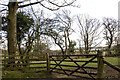
Gateway to field
Gateway to field at Holly Lodge
Image: © P Gaskell
Taken: 1 Mar 2023
0.05 miles
3
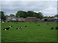
Arkleby House Farm
Large farmhouse, with a collection of new & old barns.
Image: © Matthew Hatton
Taken: 22 May 2014
0.15 miles
5
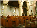
St Cuthbert's Church interior, Plumbland
Image: © William Metcalfe
Taken: 3 Nov 2007
0.20 miles
7
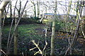
Old Reservoir, Arekleby
A concrete structure, now abandoned and overgrown. Presumably supplied the adjacent house and Farm
Image: © Bob Jenkins
Taken: 11 Dec 2005
0.21 miles
8
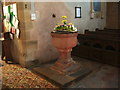
Font, St Cuthberts Church, Plumbland
Image: © Alexander P Kapp
Taken: 3 May 2007
0.23 miles
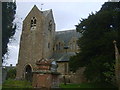
9
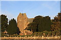
St Cuthberts Church, Plumbland
St Cuthberts Church, Plumbland
Image: © Colin Kinnear
Taken: 22 Jan 2015
0.23 miles