IMAGES TAKEN NEAR TO
Arkleby, WIGTON, CA7 2BH
Introduction
This page details the photographs taken nearby to CA7 2BH by members of the Geograph project.
The Geograph project started in 2005 with the aim of publishing, organising and preserving representative images for every square kilometre of Great Britain, Ireland and the Isle of Man.

There are currently over 7.5m images from over14,400 individuals and you can help contribute to the project by visiting https://www.geograph.org.uk
Image Map
Images are licensed for reuse under creativecommons.org/licenses/by-sa/2.0
Notes
- Clicking on the map will re-center to the selected point.
- The higher the marker number, the further away the image location is from the centre of the postcode.
Image Listing (4 Images Found)
Images are licensed for reuse under creativecommons.org/licenses/by-sa/2.0
Image
Details
Distance
1
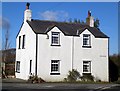
Tollhouse by the B5301, Arkleby
Tollhouse by the B5301, in the parish of Aspatria (Allerdale District), Toll Bar, Arkleby, Plumbland, CA7 2BQ.
To be surveyed
Milestone Society National ID: CB.ASP
Image: © Milestone Society
Taken: Unknown
0.15 miles
3
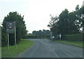
Direction Sign ? Signpost
Located on the east side of the junction of the B5301 Parsonby Road and Arkleby Road in Plumbland parish. 3 arms and annulus finial.
Milestone Society National ID: CU_NY1439
Image: © H Stamper
Taken: 11 Jun 2020
0.16 miles
4
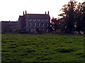
Arkleby Hall, Arkleby
This rather magnificent building is also referred to as Ellenbank Hall on the OS 1:50,000 series. The trees to the right of the photo are the start of an avenue leading to a pair of ornate gateposts which are clearly no longer used as an entrance.
Image: © Nigel Monckton
Taken: 3 Sep 2005
0.25 miles