IMAGES TAKEN NEAR TO
Mealsgate, WIGTON, CA7 1LF
Introduction
This page details the photographs taken nearby to CA7 1LF by members of the Geograph project.
The Geograph project started in 2005 with the aim of publishing, organising and preserving representative images for every square kilometre of Great Britain, Ireland and the Isle of Man.

There are currently over 7.5m images from over14,400 individuals and you can help contribute to the project by visiting https://www.geograph.org.uk
Image Map
Images are licensed for reuse under creativecommons.org/licenses/by-sa/2.0
Notes
- Clicking on the map will re-center to the selected point.
- The higher the marker number, the further away the image location is from the centre of the postcode.
Image Listing (5 Images Found)
Images are licensed for reuse under creativecommons.org/licenses/by-sa/2.0
Image
Details
Distance
1
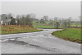
A595 junction at Low Woodnock
Looking in the direction of the West Coast (Whitehaven, Cockermouth etc).
Image: © Robert Matin
Taken: 2 Jan 2013
0.01 miles
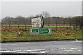
2
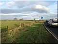
A595 at Low Woodnook
Sign at minor road junction to Blennerhasset and Baggrow.
Image: © James Emmans
Taken: 12 Dec 2018
0.03 miles
3
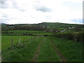
Country south of Aldersceugh
The A595 is in the middle distance.
Image: © David Purchase
Taken: 29 Apr 2018
0.05 miles
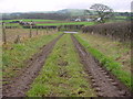
4
Sign Posts at Low Woodnook A595
Junction of the A595 with the Blennerhasset turnoff (un named).
Image: © Robert Matin
Taken: 2 Jan 2013
0.07 miles