IMAGES TAKEN NEAR TO
Kirkland Guards, WIGTON, CA7 1LB
Introduction
This page details the photographs taken nearby to Kirkland Guards, CA7 1LB by members of the Geograph project.
The Geograph project started in 2005 with the aim of publishing, organising and preserving representative images for every square kilometre of Great Britain, Ireland and the Isle of Man.

There are currently over 7.5m images from over14,400 individuals and you can help contribute to the project by visiting https://www.geograph.org.uk
Image Map
Images are licensed for reuse under creativecommons.org/licenses/by-sa/2.0
Notes
- Clicking on the map will re-center to the selected point.
- The higher the marker number, the further away the image location is from the centre of the postcode.
Image Listing (1 Images Found)
Images are licensed for reuse under creativecommons.org/licenses/by-sa/2.0
Image
Details
Distance
1
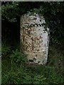
Old Milestone by the A595 near Kirkland Green
Metal plate attached to stone post by the A595, in parish of BOTHEL AND THREAPLAND (ALLERDALE District), Overgates, Kirkland Green, on grass verge, on North side of road. Carlisle red stone and curved plate, erected by the Cockermouth & Carlisle turnpike trust in the 19th century.
Inscription reads:-
CARLISLE
18 MILES
WIGTON
7 MILES
COCKERMOUTH
8½ MILES
Grade II Listed. List Entry Number: 1144497
https://historicengland.org.uk/listing/the-list/list-entry/1144497
Milestone Society National ID: CU_CLCM19.
Image: © CF Smith
Taken: 15 Aug 2005
0.24 miles