IMAGES TAKEN NEAR TO
Ireby, WIGTON, CA7 1DS
Introduction
This page details the photographs taken nearby to CA7 1DS by members of the Geograph project.
The Geograph project started in 2005 with the aim of publishing, organising and preserving representative images for every square kilometre of Great Britain, Ireland and the Isle of Man.

There are currently over 7.5m images from over14,400 individuals and you can help contribute to the project by visiting https://www.geograph.org.uk
Image Map
Images are licensed for reuse under creativecommons.org/licenses/by-sa/2.0
Notes
- Clicking on the map will re-center to the selected point.
- The higher the marker number, the further away the image location is from the centre of the postcode.
Image Listing (27 Images Found)
Images are licensed for reuse under creativecommons.org/licenses/by-sa/2.0
Image
Details
Distance
1
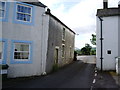
Tight squeeze
when entering Ireby along the road from Ruthwaite from the south
Image: © Alexander P Kapp
Taken: 20 Jun 2007
0.01 miles
4
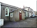
W.I. Hall, Ireby
The sign above the door says "Ireby Women's Institute 1952", which is when they bought the hall. The building dates from the 1700s, and was originally a schoolhouse.
A notice on the door, dated June 2009, says "KEEP OUT". The roof is unstable - fundraising is underway to restore this amenity, which was used as a meeting place for 15 local groups.
Update : the hall was repaired and reopened in May 2010.
Image: © Rose and Trev Clough
Taken: 27 Mar 2010
0.04 miles
5
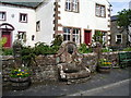
Drinking fountain or seat
With the lion's head where it is this could have been a drinking fountain or trough, but with no trough there now it could be used as a seat if the one next to it is occupied
Image: © Alexander P Kapp
Taken: 20 Jun 2007
0.04 miles
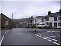
6
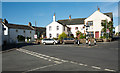
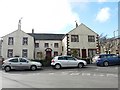
Crossroads and houses in Ireby
Ireby is a small village lying just outside the Lake District national park.
Image: © Trevor Littlewood
Taken: 12 Aug 2015
0.04 miles
9
Moot Hall, Ireby
The building dates from the late 16th century, a time when Ireby was an important market town. It has 19th and 20th century additions and alterations, and is now divided into 3 houses. The Salkeld shield of arms can be seen above the centre door http://www.imagesofengland.org.uk/details/default.aspx?id=72435 .
The garden wall and part of the Moot Hall is shown here http://www.geograph.org.uk/photo/475566 .
Image: © Rose and Trev Clough
Taken: 27 Mar 2010
0.05 miles
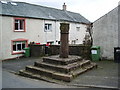
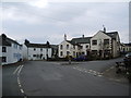
10
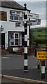
Direction Sign ? Signpost in the square at Ireby
Located on an island in the centre of the crossroads at the south end of Ireby village, Ireby and Uldale parish. 4 arms and pawn finial. See also http://www.geog.port.ac.uk/webmap/thelakes/photos/byh31.jpg and http://www.geograph.org.uk/photo/475534.
Milestone Society National ID: CU_NY2338
Image: © Mike Rayner
Taken: 12 Jul 2022
0.05 miles