IMAGES TAKEN NEAR TO
Mealsgate, WIGTON, CA7 1AD
Introduction
This page details the photographs taken nearby to CA7 1AD by members of the Geograph project.
The Geograph project started in 2005 with the aim of publishing, organising and preserving representative images for every square kilometre of Great Britain, Ireland and the Isle of Man.

There are currently over 7.5m images from over14,400 individuals and you can help contribute to the project by visiting https://www.geograph.org.uk
Image Map
Images are licensed for reuse under creativecommons.org/licenses/by-sa/2.0
Notes
- Clicking on the map will re-center to the selected point.
- The higher the marker number, the further away the image location is from the centre of the postcode.
Image Listing (2 Images Found)
Images are licensed for reuse under creativecommons.org/licenses/by-sa/2.0
Image
Details
Distance
1
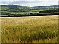
Barley, Boltongate
A crop growing beside the B5299 in an area of mostly pastoral farmland. The windfarm on Wharrels Hill is on the skyline.
Image: © Andrew Smith
Taken: 19 Jul 2008
0.21 miles