IMAGES TAKEN NEAR TO
Garthside, WIGTON, CA7 0NW
Introduction
This page details the photographs taken nearby to Garthside, CA7 0NW by members of the Geograph project.
The Geograph project started in 2005 with the aim of publishing, organising and preserving representative images for every square kilometre of Great Britain, Ireland and the Isle of Man.

There are currently over 7.5m images from over14,400 individuals and you can help contribute to the project by visiting https://www.geograph.org.uk
Image Map
Images are licensed for reuse under creativecommons.org/licenses/by-sa/2.0
Notes
- Clicking on the map will re-center to the selected point.
- The higher the marker number, the further away the image location is from the centre of the postcode.
Image Listing (7 Images Found)
Images are licensed for reuse under creativecommons.org/licenses/by-sa/2.0
Image
Details
Distance
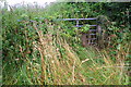
3
Benchmark on gatepost at overgrown field gateway in Oulton
Ordnance Survey cut mark benchmark levelled at 30.525m above Newlyn Datum verified in 1971
Image: © Roger Templeman
Taken: 26 Jul 2019
0.12 miles
4
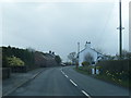
Overgrown field gate from main road through Oulton
There is an Ordnance Survey benchmark Image on the inside face of the gatepost at the right hand side of the gateway
Image: © Roger Templeman
Taken: 26 Jul 2019
0.13 miles
6
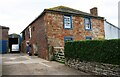
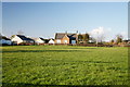
Middlemoor House
There is an Ordnance Survey benchmark Image on the near corner, left hand face, of the house
Image: © Roger Templeman
Taken: 26 Jul 2019
0.24 miles
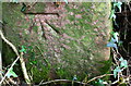
7
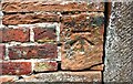
Benchmark on Middlemoor House
Ordnance Survey cut mark benchmark levelled at 25.690m above Newlyn Datum verified in 1971
Image: © Roger Templeman
Taken: 26 Jul 2019
0.25 miles