IMAGES TAKEN NEAR TO
WIGTON, CA7 0LH
Introduction
This page details the photographs taken nearby to CA7 0LH by members of the Geograph project.
The Geograph project started in 2005 with the aim of publishing, organising and preserving representative images for every square kilometre of Great Britain, Ireland and the Isle of Man.

There are currently over 7.5m images from over14,400 individuals and you can help contribute to the project by visiting https://www.geograph.org.uk
Image Map
Images are licensed for reuse under creativecommons.org/licenses/by-sa/2.0
Notes
- Clicking on the map will re-center to the selected point.
- The higher the marker number, the further away the image location is from the centre of the postcode.
Image Listing (6 Images Found)
Images are licensed for reuse under creativecommons.org/licenses/by-sa/2.0
Image
Details
Distance
1
Kirkland House
There is an Ordnance Survey benchmark Image on the near corner, left hand face, of the outbuilding
Image: © Roger Templeman
Taken: 16 Jul 2019
0.01 miles
2
Benchmark on garage block at Kirkland House
Ordnance Survey cut mark benchmark described on the Bench Mark Database at www.bench-marks.org.uk/bm112434
Image: © Roger Templeman
Taken: 16 Jul 2019
0.02 miles
3
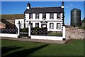
Kirkland Hall Farm.
Can't beat classic black and white for a smart appearance.
Image: © John Holmes
Taken: 9 Feb 2006
0.14 miles
5
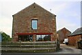
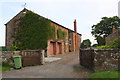
Barn conversion at Kirkland Farm
There is an Ordnance Survey benchmark Image on the barn conversion at its right hand corner left of a stone gatepost
Image: © Luke Shaw
Taken: 16 Jul 2019
0.21 miles
6
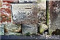
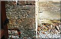
Benchmark on barn conversion at Kirkland Farm
Ordnance Survey cut mark benchmark described on the Bench Mark Database at www.bench-marks.org.uk/bm99530
Image: © Luke Shaw
Taken: 16 Jul 2019
0.22 miles