IMAGES TAKEN NEAR TO
Aikton, WIGTON, CA7 0JY
Introduction
This page details the photographs taken nearby to CA7 0JY by members of the Geograph project.
The Geograph project started in 2005 with the aim of publishing, organising and preserving representative images for every square kilometre of Great Britain, Ireland and the Isle of Man.

There are currently over 7.5m images from over14,400 individuals and you can help contribute to the project by visiting https://www.geograph.org.uk
Image Map
Images are licensed for reuse under creativecommons.org/licenses/by-sa/2.0
Notes
- Clicking on the map will re-center to the selected point.
- The higher the marker number, the further away the image location is from the centre of the postcode.
Image Listing (7 Images Found)
Images are licensed for reuse under creativecommons.org/licenses/by-sa/2.0
Image
Details
Distance
2
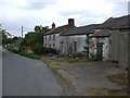
Benchmark at 136.7ft on barn at Hardcake Hall
Image: © Matthew Hatton
Taken: 24 May 2014
0.05 miles
3
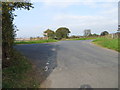
Road junction at Hardcake Hall
Looking northward.
Image: © Peter Wood
Taken: 19 Sep 2014
0.06 miles
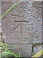
4
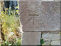
Ordnance Survey Cut Mark
This can be found on the wall of a roadside building at Hardcake Hall.
For more detail see : http://www.bench-marks.org.uk/bm61700
Image: © Peter Wood
Taken: 19 Sep 2014
0.06 miles
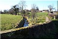
5

Tidy Hedges.
But what a mess on the roads.
Image: © John Holmes
Taken: 9 Feb 2006
0.13 miles
6
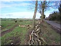
Felled Hedge.
This must have been quite a big hedge going by the amount of timber heaped up.
Image: © John Holmes
Taken: 31 Mar 2006
0.19 miles
7
Beck. at High Whinnow.
Not a lot of fall on the becks around here so the flow is quite lazy.
Image: © John Holmes
Taken: 9 Feb 2006
0.21 miles