IMAGES TAKEN NEAR TO
Aikton, WIGTON, CA7 0JT
Introduction
This page details the photographs taken nearby to CA7 0JT by members of the Geograph project.
The Geograph project started in 2005 with the aim of publishing, organising and preserving representative images for every square kilometre of Great Britain, Ireland and the Isle of Man.

There are currently over 7.5m images from over14,400 individuals and you can help contribute to the project by visiting https://www.geograph.org.uk
Image Map
Images are licensed for reuse under creativecommons.org/licenses/by-sa/2.0
Notes
- Clicking on the map will re-center to the selected point.
- The higher the marker number, the further away the image location is from the centre of the postcode.
Image Listing (6 Images Found)
Images are licensed for reuse under creativecommons.org/licenses/by-sa/2.0
Image
Details
Distance
1
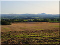
Farmland at Blackbrow Farm
Looking south towards the Lake District. Just right of centre on the horizon is the Skelton Transmitter mast, at 365m the highest structure in the UK.
Image: © Eirian Evans
Taken: 20 Sep 2020
0.03 miles

3
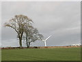
Great Orton Wind Farm
View from in front of Brunt Hill Farm looking towards the wind turbines.
Image: © phil rayson
Taken: 5 Jul 2008
0.14 miles
4
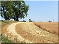
Harvest time
Black Brow, near Great Orton
Image: © Oliver Dixon
Taken: 18 Jul 2006
0.19 miles
5
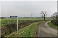
Road to Wiggonrigg
The road goes straight on, the signpost points into a field.
Image: © Richard Webb
Taken: 13 Feb 2015
0.21 miles