IMAGES TAKEN NEAR TO
Brookside, WIGTON, CA7 0HX
Introduction
This page details the photographs taken nearby to Brookside, CA7 0HX by members of the Geograph project.
The Geograph project started in 2005 with the aim of publishing, organising and preserving representative images for every square kilometre of Great Britain, Ireland and the Isle of Man.

There are currently over 7.5m images from over14,400 individuals and you can help contribute to the project by visiting https://www.geograph.org.uk
Image Map
Images are licensed for reuse under creativecommons.org/licenses/by-sa/2.0
Notes
- Clicking on the map will re-center to the selected point.
- The higher the marker number, the further away the image location is from the centre of the postcode.
Image Listing (4 Images Found)
Images are licensed for reuse under creativecommons.org/licenses/by-sa/2.0
Image
Details
Distance
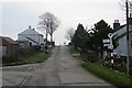
1
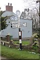
Signpost, Aikton
Cumberland County Council fingerpost.
Image: © Richard Webb
Taken: 13 Feb 2015
0.01 miles
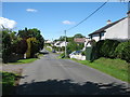
3
Aikton
A linear village, like many in the area.
Image: © Richard Webb
Taken: 13 Feb 2015
0.04 miles
4
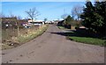
Aikton.
A farming community hence the land rover and trailer bearing down the road.
Image: © John Holmes
Taken: 10 Feb 2006
0.24 miles