IMAGES TAKEN NEAR TO
Thornby, WIGTON, CA7 0HQ
Introduction
This page details the photographs taken nearby to CA7 0HQ by members of the Geograph project.
The Geograph project started in 2005 with the aim of publishing, organising and preserving representative images for every square kilometre of Great Britain, Ireland and the Isle of Man.

There are currently over 7.5m images from over14,400 individuals and you can help contribute to the project by visiting https://www.geograph.org.uk
Image Map
Images are licensed for reuse under creativecommons.org/licenses/by-sa/2.0
Notes
- Clicking on the map will re-center to the selected point.
- The higher the marker number, the further away the image location is from the centre of the postcode.
Image Listing (7 Images Found)
Images are licensed for reuse under creativecommons.org/licenses/by-sa/2.0
Image
Details
Distance
1
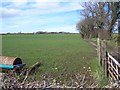
Parked farm roller.
Note the track running down the right edge of the field.
Image: © John Holmes
Taken: 31 Mar 2006
0.10 miles
2
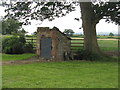
Victorian privy
At the edge of the garden at Croft Farm. Still in working order Image It was sited over a small stream, running from the left, so it was self cleaning.
Image: © M J Richardson
Taken: 3 Jul 2016
0.13 miles
3
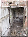
Interior of Victorian privy
The privy at Croft Farm Image If tidied up it would still be functional - a stream passes underneath!
Image: © M J Richardson
Taken: 3 Jul 2016
0.13 miles
5
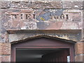
Lintel of Croft Farm house
The date is clear enough - 1661, but the inscription? Initials TI and EI, or something else? In context see Image
Image: © M J Richardson
Taken: 3 Jul 2016
0.14 miles
6
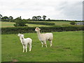
Alpaca at Croft Farm
A parent and two youngsters.
Image: © M J Richardson
Taken: 3 Jul 2016
0.15 miles
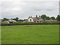
7
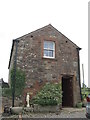
Croft Farm, Thornby
The original farmhouse, with lintel dated 1661 Image
Image: © M J Richardson
Taken: 3 Jul 2016
0.15 miles