IMAGES TAKEN NEAR TO
WIGTON, CA7 0EW
Introduction
This page details the photographs taken nearby to CA7 0EW by members of the Geograph project.
The Geograph project started in 2005 with the aim of publishing, organising and preserving representative images for every square kilometre of Great Britain, Ireland and the Isle of Man.

There are currently over 7.5m images from over14,400 individuals and you can help contribute to the project by visiting https://www.geograph.org.uk
Image Map
Images are licensed for reuse under creativecommons.org/licenses/by-sa/2.0
Notes
- Clicking on the map will re-center to the selected point.
- The higher the marker number, the further away the image location is from the centre of the postcode.
Image Listing (15 Images Found)
Images are licensed for reuse under creativecommons.org/licenses/by-sa/2.0
Image
Details
Distance
1
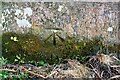
Benchmark on railway bridge south of Spittal Farm
Ordnance Survey cut mark benchmark described on the Bench Mark Database at www.bench-marks.org.uk/bm112483
Image: © Luke Shaw
Taken: 16 Jul 2019
0.08 miles
2
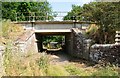
Railway bridge over track towards A596 at Spittal Farm
There is an Ordnance Survey benchmark Image on the right hand abutment of the bridge
Image: © Luke Shaw
Taken: 16 Jul 2019
0.10 miles
3
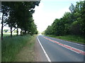
A596 towards Carlisle
Looking east near Spittal Farm.
Image: © JThomas
Taken: 18 Jun 2016
0.10 miles
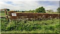
6
Field gateway from B5302 at field drain junction
Ordnance Survey documents indicate that in 1972 a benchmark levelled at 22.260m above Newlyn Datum was verified on a gatepost at this location. See www.bench-marks.org.uk/bm112436 for details
Image: © Roger Templeman
Taken: 16 Jul 2019
0.14 miles
7
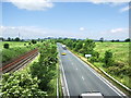
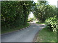
Road and railway
The A596 and the Carlisle to Barrow Railway running parallel, east of Wigton
Image: © Alexander P Kapp
Taken: 20 Jun 2007
0.15 miles
8
West parapet of bridge taking road to Dockray Farm over railway
There is a Network Rail bridge identity (CBC3/92) sign on the top left corner of the parapet, indicating the bridge is on the Cumbrian Coast Line.
Image: © Luke Shaw
Taken: 15 May 2024
0.15 miles
9
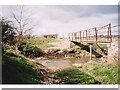
Wiza Beck, Wigton
The site a ford, now disused, with footbridge alongside.
Image: © Andrew Smith
Taken: Unknown
0.22 miles
10
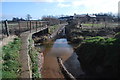
Ford at Wigton
This ford on the Wiza Beck is found along a very muddy byway near Wigton.
Image: © John Walton
Taken: 10 Mar 2015
0.23 miles